

- Home
- Companies
- SeisWare International Inc
- Software
- SeisWare - Geophysics Software
SeisWare - Geophysics Software
Map the subsurface, confirm drilling locations, and spend less time loading data and more time analyzing it without the complexities found in other software packages.
Automatically share data between the tools you use every day. SeisWare seamlessly connects with external applications to easily move data back and forth.
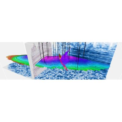
Understand the full extent of your asset with one software. Our 2D and 3D interpretation tools make it easier to map, interpret, and share seismic data in presentations.
Whether you’re a consultant or a corporate entity, our license-based subscription model and unlimited support help you juggle everything at once.
Geophysical workflows that actually make sense
SeisWare is designed with the time-strapped geophysicist in mind: It has everything you need and nothing you don’t. It’s painless to set up, notoriously quick to learn, and really, really easy to access expert support.
- Populate projects with well, log, production, seismic, and cultural data using streamlined import tools.
- Visualize geological features with regional geophysical mapping.
- Run play fairway analysis to identify potential exploration targets and prospects efficiently.
- Edit logs for accurate synthetic generation from models and extracted wavelets.
- Stretch and squeeze logs to calibrate depth data with time seismic.
- Run cross-correlation geophysical analysis to evaluate well ties with seismic data.
- Calculate and resolve misties between 2D and 3D seismic data manually and/or automatically.
- Create a static shift, phase, amplitude, and frequency-balanced dataset to enhance structural and stratigraphic interpretations.
- Integrate depth-converted seismic surfaces and attribute distributions with reservoir property grids or constants.
- Determine accurate gross and net pay rock volumes and recoverable reserves for economic analyses.
- Get detailed insight into stratigraphic features and identify anomaly extents.
- Leverage a comprehensive suite of Rock Solid Attributes, comparative wavelet analysis, spectral decomposition, seismic zone, and map attributes.
- Build velocity models using well and seismic data and refine with inter-well control points and compaction.
- Convert seismic volumes to depth and display them in dynamic 3D visuals.
- Interpret horizons and faults with manual and automatic picking tools to generate complex structural frameworks, maps, and 3D displays.
- Consolidate all relevant data into a single visual for easy interpretation and presentations.
- Manipulate data and adjust visuals in real-time for on-the-fly adjustments.