

GeoScene3D - Geological Modeling Software
Welcome to GeoScene3D, your go-to platform for learning, understanding, and interpreting your data. Our intuitive 2D and 3D visualization tools make it easy for you to make informed decisions based on your data.
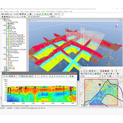
GeoScene3D offers a range of versions to suit diverse needs. From the user-friendly GeoScene3D Basic edition, enabling users to effortlessly import and visualize numerous data types in Profiles, Map Window, and 3D, to the advanced editions like GeoScene3D Layer Builder and Voxel Builder. These advanced tools are specifically tailored for geological model building, equipped with a comprehensive suite of advanced features and 2D and 3D interpolation options.
Additionally, GeoScene3D extensions introduce specialized tools for tasks such as creating water level maps, utilizing user-assisted machine learning for swift interpretation of large EM geophysical datasets, and building geostatistical models employing Multiple Point Statistics.
As the standard platform for geoscience data in Denmark, GeoScene3D undergoes continuous development in collaboration with respected organizations like the Danish Geological Survey (GEUS), the Danish Environmental Protection Agency (EPA), and major Danish engineering companies.
Capable of addressing a wide array of use cases, GeoScene3D stands as a practical, versatile, and robust program, adeptly handling the everyday challenges faced by geologists in both public and private sectors.
Designed for geologists by geologists
Explore GeoScene3D, a comprehensive geological modeling software meticulously crafted by geologists for geologists.
GeoScene3D offers a variety of versions tailored to your needs. From the user-friendly GeoScene3D Basic, enabling seamless import and visualization of diverse data types across Profiles, Map Window, and 3D, to the advanced editions like GeoScene3D Layer Builder and Voxel Builder. These editions are specifically engineered for geological model building, equipped with a rich suite of advanced tools and flexible 2D and 3D interpolation options.
Moreover, GeoScene3D extensions provide additional specialized tools, such as creating water level maps, harnessing user-assisted machine learning for swift interpretation of extensive EM geophysical data sets, and constructing geostatistical models using Multiple Point Statistics.
Discover more about GeoScene3D and unlock the full potential from your data.