LuWas - GIS-based determination of shipping-related air pollutant emissions along waterways
Program development on behalf of the Federal Institute of Hydrology.
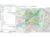
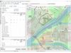
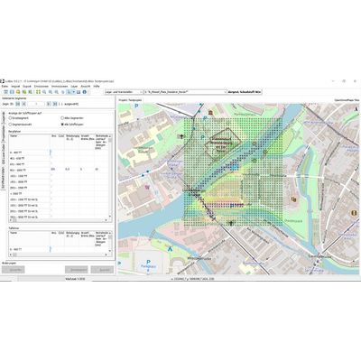
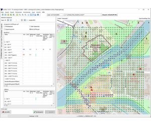
LuWas is a user-friendly, GIS-based software system (see Fig. 1) for determining shipping-related emissions and road traffic emissions and subsequently calculating the concentrations using a PROKAS-based dispersion model. The pollutants considered are NOx, NO2, PM10, PM2.5, benzene, soot, SO2, CO, HC and CO2.
LuWas consists of the following modules:
Emissions module for inland navigation
Emissions module for maritime shipping
Emissions module PROKAS-E for motor vehicle traffic on waterways
PROKAHN dispersion model
Fig. 1: LuWas program interface
The emission modules for maritime and inland shipping calculate the average annual total emissions for each waterway segment based on activity data and fleet-specific parameters for motorization, emission factors, and flow resistance. The fleet-specific parameters for these calculations are retrieved from an editable shipping database.
In the PROKAS-E emissions module, the average annual vehicle-related emissions are determined based on road capacities, average traffic volumes, and specific emission factors for light and heavy goods vehicles.
The PROKAHN module is based on our PROKAS dispersion model. Using the previously calculated emission densities or imported data, spatial conditions, and a specified wind distribution, PROKAHN determines the additional pollution. For NO2 and PM10, it also statistically calculates the frequency with which the limit values a32re exceeded.
The results are displayed using the integrated GIS interface. This allows for the overlay of maps with emission sources and the grid representation of pollutant concentrations. With a single mouse click, users can interactively modify both the input data and the calculated emissions and concentrations quantitatively based on shape attributes.
At its interfaces, LuWas offers an import function for both water and road geometries as well as for all input parameters required for further calculations. Externally calculated emission sources can also be imported into a LuWas project.
Additionally, all input data and calculation results can be exported as shapefiles for further use within or outside of LuWas.
The LASAT export function, which includes a time series generator, allows emission data to be processed and saved in a file format suitable for subsequent external dispersion calculations using the LASAT program.
Further details on the LuWas program interface can be found in the manual. If you are interested in LuWas, as well as in training and support, we will be happy to provide you with an offer.
If you are interested in WinSTACC with a single or multi-user licence, as well as for training and support, we will be happy to provide you with an offer.