
- Home
- Companies & Suppliers
- Downloads
- Autel MaxiCharger DC Fast LV3 ...
AQUAOSO - GIS Connect - Geospatial SaaS Platform for Agricultural Lenders
GIS Connect is a specialized geospatial SaaS platform developed for agricultural lenders, providing a comprehensive suite of data integration and decision support tools. This robust platform enables users to visualize loan, investment, supplier, and appraisal data in a unified geospatial view. By facilitating the integration of internal and third-party land and climate data, it supports risk evaluation and the preparation of regulatory and board reports. Through automated workflows, users can streamline data management, collection, and reporting processes. GIS Connect's analytics tools help quantify risk exposure, track climate risks, and identify risk reduction opportunities. The platform ensures secure data integration with external datasets, including parcel data, climate analytics, and wildfire maps. This cloud-based and evergreen tool also fosters team collaboration, offering features like cohort analysis and comments for seamless communication. The platform is crafted to enhance efficiency in the agricultural sector by providing essential information rapidly and securely.
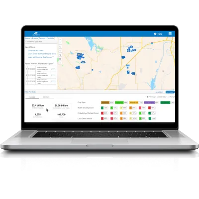
GIS Connect improves the integrity of your data. View loan, investment, supplier and appraisal data in a single geospatial view. Integrate your data with best of breed land and climate data through secure API’s. Manage board and regulatory requirements with automated geospatial data management, information collection workflows, and reporting.
Overview
GIS Connect is a powerful suite of analytics and data management tools that can help you achieve your goals of managing your data geospatially, quantifying risk exposure, assessing and tracking climate risks impacting your portfolio, and aiding in risk planning and mitigation.
- Quickly identify and monitor risks
- Find opportunities for risk reduction
- Collaborate with your team
- Securely integrate your data with 3rd party data sets
- Generate managerial reports
GIS For Your Data
- Easily integrate and search your loan, collateral, appraisal, investment and supplier data sets and run analytics by parcel, borrower, or operation.
- Complete multi-parcel searches by simply drawing directly on the map to view detailed information.
- Prebuilt APIs with the data and software tools you use daily.
Workflow Management
- Exportable parcel or portfolio reports can facilitate senior level management communication.
- Improve customer relationships with on-demand reporting.
- Add notes and attachments to your maps, reports, and customer data as well as custom data fields.
Cohort Analysis
Easily compare and discover cohorts of suppliers, borrowers, and sales to expedite communications, appraisals, origination and decisioning.
Team Collaboration
Include comments for your colleagues, making it easy to collaborate with your team with a retained history of conversations.
Secure Integration
See all of your data overlaid against parcel data and ownership records, wildfire maps, endangered species, small disadvantaged communities, AQUAOSO’s Water Security Platform, and other 3rd party climate analytics.
Cloud-Based & Evergreen
- Enterprise and bank grade security.
- Secure APIs for advanced analytics and portability.
- Industry accepted best practices and frameworks.