
- Home
- Companies
- NOAA Office of Response and Restoration
- Software
- GNOME - General NOAA Operational ...
GNOME - General NOAA Operational Modeling Environment Software
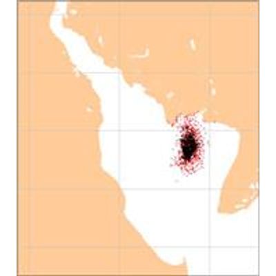
GNOME (General NOAA Operational Modeling Environment) is the modeling tool the Office of Response and Restoration`s (OR&R) Emergency Response Division uses to predict the possible route, or trajectory, a pollutant might follow in or on a body of water, such as in an oil spill.
GNOME supports different user experience levels through user modes. To quickly set up spill scenarios customized for each incident, OR&R modelers use GNOME in Diagnostic Mode, which enables them to incorporate a number of outside atmospheric and oceanic circulation models. However, anyone can use GNOME in Standard Mode and with the help of regionally specific location files, set up their spill scenarios to:
- Predict how wind, currents, and other processes might move and spread oil spilled on the water.
- Learn how these predictions of where and how oil might move are affected by uncertainty in observations and forecasts for ocean currents and wind.
- See how spilled oil is expected to change chemically and physically, known as weathering, during the time that it remains on the water surface.
To use GNOME, you describe a spill scenario by entering information into the program. GNOME then creates and displays an oil spill "movie" showing the predicted trajectory of the oil spilled in the scenario. In addition to this animation, GNOME estimates the amount of oil beached, still floating, or evaporated at specific times. Along with GNOME, most users also will want to download the Location Files for their regions of interest, such as the Gulf of Mexico or Pacific Region. Location Files contain prepackaged tide and current data and make it easier to work with GNOME.