
- Home
- Companies
- Drone Harmony AG
- Software
- Drone Harmony - Inspection and Mapping ...
Drone Harmony - Inspection and Mapping Software
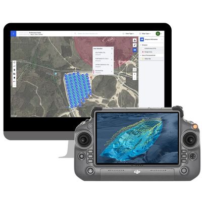
Drone Harmony’s Mapping & Inspection software is a holistic data capture solution for commercial mapping and inspection designed at professionals and enterprises that seek to maximize productivity of their drone workflows. Drone Harmony features fully integrated 3D web and mobile applications that cover every aspect of data acquisition, from flight planning to flight automation and data review. Drone Harmony supports all commercial DJI drones and a full spectrum of devices, including Android, iOS and most DJI monitors (Smart Controller / RC Pro / RC Plus and CrystalSky).
Plan Complex Missions with Ease
Access the most powerful 3D data capture software from any web browser or mobile device, supporting all common mapping and inspection use cases: Surveying, 2D Mapping, 3D Mapping, Mining, Construction, Industrial Inspection, Solar Inspection, Oil & Gas and more. Enjoy the richest feature set of automated tools, combined with flexibility of making arbitrary edits to flight missions in 2D and 3D. Enable seamless collaboration between planners, field teams and data engineers.
Fly and Gather Data with Confidence
Empower any field operator to become a drone pilot with safe, automated drone flights. Reduce the learning curve to a minimum and gain acceptance for your drone program from the field crews by proving them with a simple to use, safe and intuitive flight app.
Review Flights and Captured Data
Access all flight logs and image metadata files after the flight in the web app to organise and preview captured data. Overlay the image data on the Drone Harmony interface to gain initial insight into the state of the asset and plan additional captures accordingly. Synchronise flight logs automatically to your compliance software provider.