

LiORA - Version Insights -Site Contamination Real-Time Monitoring Software
Delivers continuous subsurface monitoring by combining LiORA`s proprietary sensors with AI-powered software. Replaces quarterly sampling with daily measurements. Provides real-time plume modeling, automated alerts, and regulator-ready evidence of plume stability and remediation effectiveness.
What it monitors
Petroleum hydrocarbons (BTEX, F1 fractions), chloride for brine contamination, CO2, CH4, O2, temperature, pressure, and moisture. Sensors transmit measurements daily via long-range wireless (LoRaWAN), stored both on device and in the cloud platform.
How it works
Proprietary subsurface sensors are deployed into existing 2" monitoring wells — no new drilling required. The LiORA platform ingests the continuous data stream and runs live plume modeling, anomaly detection, trend analysis, and geo-based spatial intelligence. Includes all LiORA Trends analytics plus real-time sensor feeds, automated threshold alerts, and regulatory supporting reports. Historical data and platform configurations carry forward seamlessly from LiORA Trends.
Data & Security
Data measured, transferred, and securely stored daily via LoRaWAN. Onboard backup ensures no data loss during connectivity gaps. All data encrypted in transit and at rest. Regular security audits. Users maintain full control over data access permissions.
Performance
- Sensor reliability: 98.6% uptime
- Data frequency: 48 measurements per day (vs. 4 per year with quarterly sampling)
- Annual data points: daily readings per sensor
- Time to actionable insights: 1 week from installation
- Implementation timeline: 3-4 weeks from site assessment to full activation
Key Capabilities
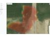
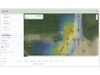
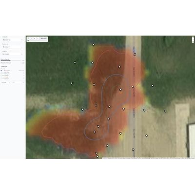
- Live Plume Modeling: Continuously updated AI models fed by real-time sensor data
- Plume Stability Heatmaps: Predicted contaminant behavior over time
- Automated Alerts: Instant notification when unexpected changes occur
- Multi-Variant Plumes: Complex site modeling with multiple contaminant types
- Soil Vapor Intrusion: Vapor pathway assessment included
- Geo-Based Insights: Spatial intelligence tied to site geography
- Regulatory Supporting Report: Defensible documentation for closure submissions
- Dedicated Technical Expert: Ongoing support for regulatory navigation
- Portfolio-Wide Anomaly Detection: Real-time dashboards across all active sites
How to get started
Begins with a site assessment to evaluate sensor placement and deployment planning. Professional installation is completed in weeks 2-3. Full intelligence activation — including team training, historical data integration, and custom alert configuration — is complete by week 4.