

MALÅ - Version Object Mapper 2018 -Utility Mapping Software
Object Mapper is an easy-to-use visualization utility mapping software for processing, analysis, and interpretation of utility detection GPR data acquired by MALÅ systems – including MALÅ Easy Locator Pro WideRange HDR.
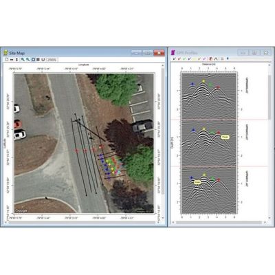
The Object Mapper utility mapping software is appreciated by its users for its simplicity and effectiveness to deliver results. The new version – Object Mapper 2018 – has several enhanced features including support of online maps. The utility mapping software supports both Object Mapper GPS projects and Baseline projects, which means that a GPS project is utilizing positioning coordinates from a GPS receiver and a Baseline project acquires coordinate points with reference to a physical Baseline drawn up at onsite. Experience the advantages of MALÅ Object Mapper 2018 utility mapping software. Download the software today and receive a 14-day free trial.
- Simple handling of GPR utility mapping data
- Parallel Data view and Site Map
- Online maps support (Google Maps)
- Support of Object Mapper GPS project and Baseline projects
- Selection of color-markers to identify each object
- Export of results to CAD/GIS software through DXF
- Import of the MALÅ Easy Locator Pro WideRange HDR data
- Support for both Lat./Long. and UTM coordinates
- Utility and object mapping