

FarmIT 3000 - Maps and Mapping Software
FarmIT 3000 enables you to use two types of maps, built in GOOGLE maps or your own custom map. Maps can be linked to field records or part field areas and used to display information for example, field usage, crops, grass cover, animal locations, key features, streams, cairnes, hedgrows etc . Providing an easy to use graphical representation of your farm.
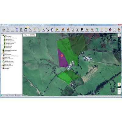
Embedded Google Maps
Google is leading the way in easy to use mapping tools based around GPS data. Although we have developed our own mapping software, Google Maps and specifically the satalite images make it rather hard to beat. So why not embrace it.
With google maps embedded into farmIT 3000 you can access your map, from your desktop (FarmIT 3000), from FarmIT online and from your android phone with FarmIT Mobile for andriod (available from the Google Play Store!).
You can create multiple maps, you can even clone them, and use the maps to display Field Type, crop data, Grass Cover data(field plate readings) and animal location data, even drag and drop grazing records!.
You can also include walls, hedgerows, roads, streams, lakes ponds etc etc The list is growing daily. Even boreholes, NVZ areas are also on the horizon.
Google Maps, GPS Data and Android Phones
Of course manually editing your google map can be rather teadious so why not use your phone and GPS coordinates!. Well you can, The FarmIT Mobile App allows you to record your walk round the field, then add it to your map and link to your field records. You can even create part field areas, if your not using all the field for the same purpose. For example grazing a part of the field or planting with buffer strips.
What about Areas and Lengths?
Well if you draw on your map we will tell you the field area in Hectares and Acres, If your draw a line for a fence or pipe , we can tell you the length.
P.S - The RPA Land Parcels Website
If you are lucky enough to Farm in England and have an SBI number, then the RPA may be able to help you get started. Log into the Land Parcel website with your SBR number, you will then be able to download all you fields including GPS coordinates in a form we can actually import!. Thus creating you field records and map in seconds.
Give us a call to find out more. For we have only just started!