

- Home
- Companies
- MetOceanView, Division of MetOcean ...
- Software
- MetOcean - Version MetOceanView - ...
MetOcean - Version MetOceanView -Operations and Planning Software
Increase safety and save time and money for your marine operations. Online access to affordable, customised marine weather forecasts for your site. Designed with industry, for industry. Supported by our team of maritime experts and oceanographers.
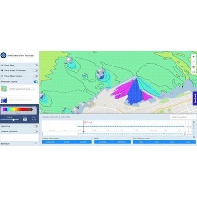
- A high-resolution web-based weather delivery tool for management of marine operations.
- A robust delivery platform that allows you to access, monitor and manipulate the marine weather information required for effective planning and operations
- A one-stop shop for both forecast and historical weather information.
- Access to information at any time - online, or sent to you via email.
- Increase safety, save time and save money for your marine operations by using the accurate real-time weather information.
- Access affordable, customised marine weather forecasts for your site.
- Designed with industry, for industry.
- Supported by our team of maritime experts and oceanographers.
- Adverse and uncertain ocean conditions are costly to marine industries.
- Avoid unnecessary port closures and risks to personnel safety.
- Global-resolution forecasts cannot predict the exact conditions at your site. MetOceanView provides accurate site-specific weather information.
MetOcean Solutions` in-house state-of-the-art oceanographic and atmospheric forecast and hindcast models provide detailed, reliable weather information for anywhere on Earth. Our web-based tools allow offshore and coastal operators, fleet and marine managers to access weather data and make informed decisions.
Accurate, reliable and customisable marine weather forecasts.
High resolution models
- Wind, wave and current forecasts for your specific location.
- Our customised models allow us to accurately forecast conditions at scales ranging from global to hyper-local (e.g. a berth within a port).
Plan your operations
- We offer hourly forecast data to 7 days ahead plus long range guidance with customised data resolution.
- Access your forecasts via the MetOceanView website, any time you need, or sent to you via email. Forecasts are updated every 6 hours, so you always have the latest information.
- Real-time observations
Real-time observations
- Real-time observations are available thorugh our MetOceanView platform.
- Weather monitoring is provided as required and can be interfaced with the weather forecast information.
Tailored to your needs
- Forecasts are shown as charts, tables and graphs, allowing you to zoom in on areas of interest and set safety limits specific to the operations in your area.
- Forecast data can be related to specific operational issues providing simpler, impact based, decision making information.
Accurate, localised historical weather data for your site.
Time series of metocean parameters
Download time-series of ocean and atmospheric parameters at specific locations, including 2D wave spectra and kinematics for anywhere on the planet.
Our numerical models generate accurate historical wind, wave and current data for any location on Earth. View our existing datasets or contact us to discuss getting historical weather data for your desired location.
Key baseline information
Access gridded data of metocean parameters in different data formats.
Generated by our team of expert scientists using a suite of in-house atmospheric and oceanographic models, our historical data archives reach back to 1979.
These datasets offer key baseline information for project scoping, offshore and coastal design, project planning and environmental impact assessments.
A platform to access and download analytics and time series of historical marine weather data – anywhere on Earth, exactly where you need.
Take a quick tour and discover all the capabilities of the Hindcast Portal freely available to you.