

MIPAR Image Analysis
- Home
- Companies
- MIPAR Image Analysis
- Software
- MIPAR - Drone & Survey Software
MIPAR - Drone & Survey Software
Automated railtrack inspection via drone imaging. Railtrack components quantified from drone imagery as part of a weekly railway inspection mandated by the federal railroad administration (FRA).
Most popular related searches
remote sensing
inventory management
filter paper
contamination monitoring
inspection drone
contaminant detection
paper manufacturer
drone inspection
- Remote sensing of houses and trees in residential community
- Objects automatically detected and classified into houses and trees, with a count of each class reported
- Filter paper contaminant classification and size measurement
- Detected contaminants are classified into predefined types and the size and shape reported.
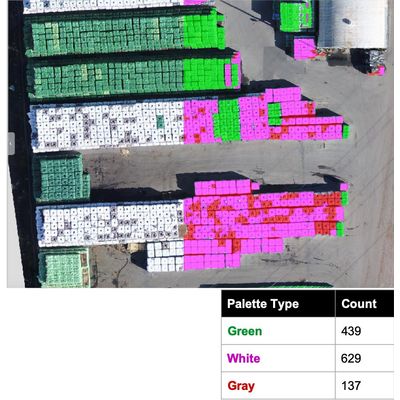
- Inventory count of palette types in storage field
- Palettes detected and classified into their different types. Enabled drones to be used for automated inventory management of vast storage fields.