The app will instantly calculate position, distance and area data for mapped objects. Mapping can also be enhanced with geophotos taken with the device. Users have access to built-in satellite, street and topo maps, even in locations where there is no internet connection.


AgTerra Technologies, Inc.
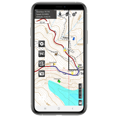
AgTerra Technologies - Version MapItFast -Mobile GPS Mapping App
MapItFast from AgTerra Technologies is a versatile GPS mapping app designed for mobile devices, bringing efficiency to field operations. The app supports mapping points, lines, areas, and photos with a single tap on both Apple and Android devices, functioning even offline in remote areas. It allows real-time collaboration and data sharing among team members, enabling enterprise-level field operation management. Users can create custom electronic forms with Strider Forms & Reporting, integrated with MapItFast, and automate report generation. The professional version offers advanced features like custom basemaps, data dictionary dropdowns, and robust user management via the MapItFast Web console. Data exports in formats like shapefile, KMZ, and GPX are supported for compatibility with third-party GIS software. MapItFast caters to diverse applications such as crop consulting, invasive species control, expense reporting, and lab sampling, revolutionizing data collection and reporting in field operations.
Most popular related searches
invasive species control
data acquisition system
GIS software
mapping system
mapping software
GIS mapping
laboratory sample
invasive species
real-time mapping
synchronization controller
Finally, here is mapping software that is truly simple and really easy to use in the field. AgTerra’s MapItFast mobile app uses innovative One Tap to Map functionality for both GPS and hand drawn mapping, transforming mobile devices into versatile GPS mapping machines. A free, personal version of MapItFast is available for Android and Apple smartphones and tablets. Mapping can be done using the GPS your device already has or by drawing objects in by hand. MapItFast makes it easy to map objects both ways:
- Use one tap to simultaneously map points, lines and polygons based on GPS location
- Use a long press to draw points, lines, and polygons by hand without using GPS
The paid, professional version of the app extends the capabilities of MapItFast even further. Paid users can upload custom basemaps and quick-add map objects using data dictionary dropdowns with custom symbology. Paid users have access to AgTerra’s browser-based mapping console, MapItFast Web, where administrators can organize map projects, follow field activity in real-time and set robust user and group permissions and view, edit, export and share the data with others.
Data can be exported in shapefile, KMZ and GPX formats for use in third-party GIS software such as ArcGIS and Google Earth. To learn more about the professional version of MapItFast or to register for an account, contact AgTerra today! MapItFast’s data gathering capability is extended even further with the fully integrated Strider Forms and Reports. Custom attributes can be quickly added to absolutely any map object using the convenience of electronic forms straight from the mobile app. Strider even generates automated reports for each form submission, so you can share you field work with others instantly.
Map Projects Offline
Carry all of your projects and maps in your pocket! MapItFast users are able to work on projects at any location, even when there is no cell service or internet. Additionally, MapItFast comes with aerial, street and topo maps, or you can use your own. Maps on devices may be configured with unique icons, layers and data dictionaries. Users can collect spatial data and complete digital forms and reports from the field. Once back in range of an internet connection, all data collected is automatically uploaded to your secure web-based account for easy access to authorized users.
Smart Digital Forms
Attributes may be added to any mapped object using one or many electronic forms. Easy to build, but advanced forms may be designed with pre-fill, validation, calculations, form logic controls and more. Printable reports containing maps and photos may be emailed from the field. APIs are also available that integrate the data with third party mapping and database systems.
Centrally Warehoused
All of your data is centrally managed and can be viewed in real time as map and tabular data are automatically synced to your secure account. MapItFast includes online capabilities to manage data, print maps and reports, and export to other database and GIS systems in KMZ and shapefile formats. Data may also be automatically synchronized with pre-existing geodatabases.
Designed with Field Users in Mind
Every feature available in MapItFast has resulted from countless hours of field use and our customers’ experiences. MapItFast is field proven to handle the job even while working in the most remote areas under challenging conditions. Furthermore, organizations can take advantage of the work order features included with MapItFast that give administrators the ability to manage user assignments and completion status in real time over large geographic areas.
One Tap to Map, Even While Offline
Use the device’s GPS or draw to easily capture points, lines, and polygons and add photos and attributes in a single tap, even while offline.
Automatically Synchronized
Share contributions from all your team members in real-time as data automatically syncs across all devices in the field and at the office.
Easily Accessed Anywhere
Use any Internet web browser to view all projects via an online map. Filter and find according to name or form content attributes.
Really easy mapping – MapItFast breaks the barriers to mapping and data collection in the field. The software is packed with powerful features while maintaining ease of use and an unmatched price. Compare our features with others. Here are some of the most compelling reasons you will want to use MapItFast as your mapping and data collection system:
- Leverage Android and Apple devices; no special GPS hardware to buy
- Use only one tap to map for easy, simultaneous mapping for points, lines and polygons
- Import custom raster maps and vector layers
- Combine mapping with smart digital forms
- Collect data offline
- Create buffers and donuts
- Deliver printable reports from the field
- Manage multiple projects and data with the web mapping dashboard (included)
- Use tools for searching, editing, buffering, data dictionaries, exporting and more
- Provide single user, group access and permission controls
- Synchronize projects and data in real-time to keep everyone current
- Automate map style changes whenever data is updated
- Integrate with pre-existing database and GIS mapping systems via API
- Virtually eliminate training to get users mapping and filling forms faster
- Streamline and quicken workflow processes
- Interface with SprayLogger, FoggerLogger, SnapMapper and TrackItFast data logging hardware to automate mapping from equipment operations
MapItFast is FREE for personal use. A paid version enables cloud features, custom maps and electronic forms for powerful and affordable enterprise use. See for yourself how MapItFast helps organizations mobilize their business for increased efficiency, productivity and critical decision-making.