

NavVis - Version IVION Core -Mobile Mapping Solution
A reality capture platform for laser scanning and AEC professionals. Manage your 3D scans with intuitive tools for creation, collaboration, and publication. NavVis IVION Core makes mobile mapping workflows more efficient, speeds up model creation and delivery, and adds value to your data.
The need for high-end computers, specialist software and technical skills can limit reality capture data to select individuals. With NavVis IVION Core, point clouds and panoramic images are transformed into intelligent spaces which are accessible to every stakeholder from any standard web browser.
- Efficiently process, register, publish, and deliver your scan data online
- Inspect, plan and measure with a building visualization that`s easy to navigate
- Improve efficiency by giving your team and clients access to the full point cloud data from anywhere
- Optimize scan-to-BIM workflows and boost verification efficiency
- Go beyond modeling and offer your clients even more value with a new kind of deliverable that extends the use of 3D scan data
Maps and custom floorplans
Give your customers an entirely new way to use and interact with floorplans. NavVis IVION Core automatically generates an AI-based map to give an overview of the entire site. Upload custom maps that have been designed in photo editing software.
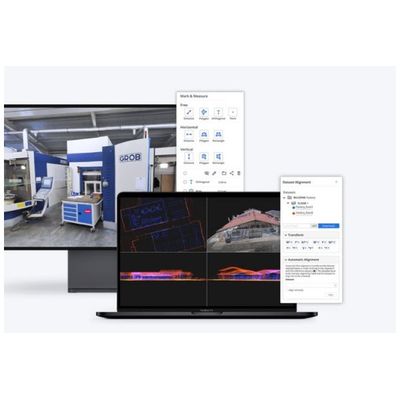
Mark & Measure
360° immersive images are not just digital images. The pixels in these images are enriched by laser scans, which makes it possible to interact with scanned spaces as if you on site. Conveniently take, organize in folders, and share point-to-point measurements with Mark & Measure. Display exact coordinate information and take point and orthogonal measurements for further precision.
Crop and download point clouds
NavVis IVION Core allows users to download sections of a point cloud in different file formats, so you can edit your point clouds and import them into other software programs. Make a selection in the point cloud with the 3D crop box to only download what you need.
Align and register scans
Align and register of all your NavVis scans as well as scans from third party devices. This feature includes the ability to perform automatic cloud to cloud alignment.