

- Home
- Companies
- IBL Software Engineering
- Software
- IBL - Online Weather Software

IBL - Online Weather Software
Web Service module opens Visual Weather’s visualization and data processing capabilities to all Service-Oriented Architecture (SOA) frameworks. This concept allows Visual Weather users to create new demand-driven batch production mechanisms. Web Services build a bridge between Visual Weather and 3rd party systems in the following key areas: Interfacing with other Geographical Information Systems (GIS) based on OpenGIS standard Web Service protocols. Exposing custom data decoding, computing and post-processing functionality of Visual Weather to bespoke applications using Python API with XML, JSON, GeoJSON, CSV or any arbitrary output format.
Visual Weather Web Service module implements the following OpenGIS compliant services:
Exposes satellite or radar imagery or NWP data (both deterministic and ensemble parameters) in a form of mathematical gridded “coverage” in GRIB1, GRIB2, NetCDF, KML, JSON, GeoJSON or GeoTIFF format. Visual Weather allows in addition to accessing original grids to perform on-demand statistical processing such as time range averages, ensemble probability thresholding, vertical maximums etc.
Exposes aviation SigWx features (clouds, jetstreams, icing areas, etc.) as well as aviation observation/forecasts and warnings (METAR, TAF, SIGMET etc.) or basically any kind of in-situ data such as observations (SYNOP, AWS, lightning etc.) in GML (Geography Markup Language). Clients can apply any OGC filter (aka SQL query) to filter observations based on desired criteria.
Important aspect of building a Service Oriented Architecture or a web application is ensuring that all services scale well with client demands. IBL has a proven expertise in delivering well performing and scalable web service solutions based on:
If you want to build your public weather web site or local Intranet portal or perform weather forecasting over Web from any location in the world then Online Weather is the right product for you, containing:
- Web Portal with Content Management System where you can publish all your weather products created in Visual Weather and author your custom text content or layout.
- Interactive forecasting tools implemented as Rich Internet Applications running in Web Browser allowing to shift forecasting process from traditional workstation to lightweight web browser or tablet environment while keeping flexibility.
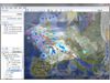
Weather data and map visualization with layers, zooming, panning and readouts of detailed point information at mouse position, all updated in real time. Available layers include geospatial backgrounds, observations, NWP data, satellite and radar layers, lightning etc.
Interactive cross-sections and meteograms composed of both observations and NWP data for any trajectory or location.
Upper air profiles from NWP data displayed for any location selected on the map.
Split-screen multi views with different time frames, models or levels with synchronised zooming.
Production of text forecasts with final product preview functionality featuring syntax checking.
Collaborative production of graphical forecasts such as SIGWX charts, Low-level regional forecasts, surface analysis charts.
Interactive and configurable role-based task sheets driving all forecasting workflow & weather observation monitoring.