

OpenSite Designer - Optimizing Outcomes Software
OpenSite Designer is a new application that employs an open modeling environment for the project delivery of site design projects from concept to completion. The application provides complete detailed design capabilities for rapid site modeling and analysis, earthwork optimization and quantification, drainage and underground utility design, automated project deliverables, and more.
OpenSite Designer provides the most comprehensive site design workflow available including reality modeling, geotechnical, underground utilities, stormwater drainage, terrain modeling, detailed drawing production, and visualization. Using OpenSite Designer, you can:
- Assemble context data rapidly from a variety of sources, such as point clouds, 3D reality meshes, terrain data, images, and geospatial information to bring real-world settings to your project.
- Achieve exponential modeling performance gains with the model-centric production of design deliverables.
- Enable users to share project information across teams, locations, and disciplines with precision and security.
- Use Catalog Services to manage and deliver functional components for consistent generative design across the engineering team.
- Access Documentation Center to produce multidiscipline documentation for all work on assets across the project.
- Share realistic visualizations with the public and stakeholders to gather feedback, improve public engagements, and speed project approvals.
Access manufactured components
Access the Component Center, a set of cloud services enabling faster access and more consistent use of manufactured components and organization or project-specific content and standards. Use the parametric components in specific applications and industries across multidiscipline project teams, while supporting knowledge sharing between personnel and enabling the persistence of component information across the asset lifecycle.
Automate drawing production
Utilize the Documentation Center for automated production of high-quality drawings, including multidiscipline documentation sets, which are consistent across the entire project. Get a live view of the project in sheet orientation. As the design changes, so will the sheets. Make edits directly in the sheets and the application will update the source geometry.
Design in context
Clearly understand existing conditions and accelerate design modeling workflows with the ability to easily integrate imagery, point clouds, and 3D reality meshes into design and construction models. Integrate geospatial information to ensure that models are precisely geospatially located.
Develop site designs
Quickly create, revise, and optimize multiple design scenarios for commercial, industrial, and campus projects to determine optimal site plans for each project. Create parking lots, streets, sidewalks, buildings pads, and other design features with auto-drawing capabilities.
Generate grading and stormwater drainage plans
Quickly create, revise, and optimize conceptual layouts with grading and stormwater drainage plans while viewing associated costs. Generate cut and fill estimates on the fly. Save time and money while reducing project risks with the ability to generate fully cost-optimized conceptual site plans and takeoff budgets in minutes.
Integrate multidiscipline models in site designs
Ensure models represent all project information by incorporating site designs, drainage, driveways, buildings, and other site features. Import models to readily view the model holistically in the proposed environment.
Model, analyze, and design complete stormwater and sanitary sewer networks
Create, manipulate, design, and analyze stormwater and sewer networks that are fully integrated with your roadway designs. You can manipulate networks in plan or profile views, displaying not only the drainage model but also other utilities.
Perform design-time analysis
Ensure visibility into overall project performance with design-time analytics to achieve optimized design outcomes for a wide variety of analysis such as drainage, terrain, safety, grading, site visibility, and more.
Reuse common design layouts
Use civil cells to ensure standards are implemented, increase design quality, and eliminate the need to repeatedly design common configurations. If you can design it, a civil cell can handle it. There is no limit to the simplicity or complexity of a civil cell.
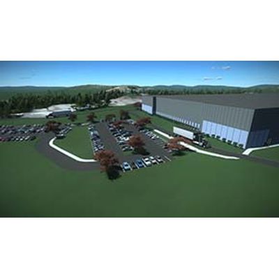
Visualize designs
Experience your designs in real time with constraint-driven templates, a context sensitive intuitive interface, and dynamic 3D modeling. Visualize the design at any time and on demand within the modeling workflow. No translations, software, or special workflow process is needed.