

- Home
- Companies
- Clearpath Robotics by Rockwell ...
- Software
- Clearpath - Version OutdoorNav - ...
Clearpath - Version OutdoorNav -Outdoor Autonomy Software
OutdoorNav is an outdoor autonomy software platform designed for vehicle developers, OEMs and robotics researchers. Compatible with Clearpath outdoor mobile platforms and third-party vehicles, OutdoorNav provides reliable, industry-leading GPS-based navigation for faster, more efficient autonomous vehicle development.
- Fast-track Autonomy Development
- Turbocharge your autonomous vehicle development and get your off-road vehicle to market faster.
- Save on Development Costs
- Gain advanced autonomy while avoiding extensive staffing, engineering and development costs.
- Easy to Integrate
- Easily add OutdoorNav to your off-road vehicle with a well documented, highly configurable API, ROS compatibility, reference designs, user guides and more.
- Industry-leading Autonomy
- OutdoorNav delivers robust and reliable localization through proprietary sensor fusion, continuous path planning and monitoring, obstacle detection and avoidance, and more.
OutdoorNav software provides robust, reliable and precise point-to-point GPS-based navigation through proprietary sensor fusion of GPS, IMU, LiDAR and platform odometry. With built-in continuous path planning, and obstacle detection and avoidance, outdoor vehicles can navigate autonomously and precisely between user-defined waypoints collision-free. Customized tasks can be added to waypoints, such as capturing sensor data or imagery at specific locations, and auto-docking capabilities allow for hands-off battery charging.
Use the built-in Teleoperation mode to confidently operate your vehicles remotely via cellular connection using an on-screen or physical joystick. Onboard sensor data from network cameras, LiDARS and other integrated components can be easily visualized in real-time through the web-based user interface. Vehicle operation can be conveniently switched from autonomous mode to teleoperation and vice versa at any time during missions.
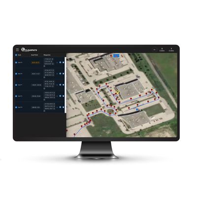
OutdoorNav’s built-in web-based user interface makes it easy to build, edit, monitor and manage autonomous missions, assign customized tasks to waypoints, visualize data from connected sensors, and view the vehicle’s live position on an interactive map. At a glance, capture essential status data from the vehicle including velocity, signal strength, e-stop status, vehicle battery charge and more.
With a well documented Application Programming Interface (API), build and expand the autonomous navigation system by integrating your own custom ROS-based applications and graphical interfaces, or by connecting third-party fleet management tools.