

SPH Engineering
- Home
- Companies
- SPH Engineering
- Software
- SPH Engineering - Version UgCS - ...
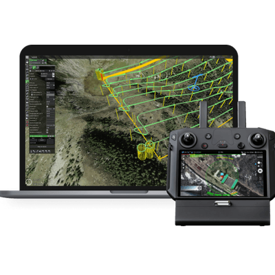
SPH Engineering - Version UgCS -Professional Desktop Drone Flight Planning Software
FromSPH Engineering
UgCS is the tool of choice to create and execute automated drone flights even in areas with complex terrain. It supports data import from KML/CSV and the use of custom digital elevation models (DEM)
Most popular related searches
LiDAR survey
photogrammetry
LiDAR
digital terrain modeling
vertical LIDAR
LIDAR application
inspection drone
drone inspection
inspection system
terrain modeling
- Plan LiDAR surveys with automatic IMU calibrations
- Built-in photogrammetry, circlegrammetry, corridor and vertical scan tools
- Flight planning in full 3D with terrain following
- Digital Elevation Model (DEM) and map overlay import
- Installs locally, works offline
- Supports most popular drones
- LiDAR
- Vertical inspections
- Mining
- Photogrammetry
- Magnetic and other low altitude surveys
- Powerline inspections
- Test counter-drone systems