


SiteMap - Project Management Software for Construction
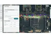
The SiteMap® Project by GPRS is a comprehensive project management software designed to enhance the control and management of construction projects. It facilitates team coordination, workflow optimization, and quality assurance in the documentation of as-built information. The platform provides a unified access point for all members to ensure information consistency and flow, making it accessible 24/7 via any computer or mobile device. It allows project managers to own and manage all data, supporting data integrity with real-time updates. The software features a Digital Plan Room to secure and centralize subsurface files, effectively preventing unauthorized data edits and unauthorized access. This tool is pivotal for avoiding utility strikes and potential damages, thanks to its integration with GPRS's highly accurate subsurface data. SiteMap® supports customizable communication, aligning team members' objectives with precise geographically segmented data, and maintains every version of digital as-builts to ensure detailed project documentation. The solution is designed to safeguard project budgets, timelines, and reputations.
- Put everyone on the same page with a single source of truth that is accessible to everyone who needs it for the life of your project, 24/7 from any computer or mobile device.
- Control information flow to put the right information into the right hands at exactly the right time.
- Own & access all of your project data, whether ordered by you or your subcontractors. If GRPS did the work, you can see it all in SiteMap®
- Strip away confusion by providing customized communication that reinforce each team member’s individual objectives with specific geographically segmented data.
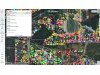
- Print, save, or copy your SiteMap® data to communicate real-time subsurface as built information in whatever format suits your needs.
- Retain and access every iteration of your digital as builts to securely document and reference your project’s progress
- Secure your subsurface files, maps, and drawings in one centralized Digital Plan Room accessible to only those you designate through the life of your project.
- Safeguard the real-time accuracy of your subsurface data against unauthorized uploads or edits.
- Protect your jobsite, your team, your budget, and your reputation with GPRS’ 99.8% accurate subsurface data to prevent utility strikes and damages that could derail your timeline.