

QZ Solutions Sp. z o.o.
QZSolutions - Version SoilEO -Remote Field Abundance Maps Software
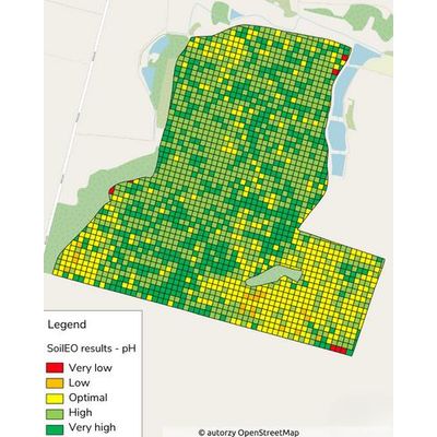
Remote field abundance maps, based on which precise fertilization maps are created.
Most popular related searches
Optimization
Offer your customers precise fertilization maps.
Speed
The map is ready in a few days.
Automation
Replace the labor-intensive process of soil sampling.
What is SoilEO?
SoilEO is a remote soil survey service based on hyperspectral imagery and artificial intelligence algorithms.
SoilEO, are precise fertilization maps based on nutrients in the soil, such as:
- magnesium (Mg),
- potassium (K2O),
- phosphorus (P2O5),
- pH.
Knowledge, on the content of these components, is the basis for optimal fertilization of fields.
SoilEO is an alternative to classical soil sampling.
Why is SoilEO the future?
- It delivers results quickly, in a few days, without waiting for results at the lab
- It uses the most modern technology available on the market
- The results of field abundance are obtained at a resolution of 6 ar
- Creates precise fertilization maps based on abundance maps, ready to use
- Eliminates human error in the collection of physical soil samples
How does our SoilEO service work?
Step 1
You indicate the Customer field.
Step 2
We acquire hyper-spectral images of the field.
Step 3
We analyze data using AI algorithms.
Step 4
We send a ready map of macronutrient abundance.