
Radicle - Soil Analysis Process Management Application
The Radicle App is an innovative platform designed to streamline the process of soil analysis, providing users with comprehensive control over every step of the journey from field sampling to result interpretation. This application allows for the creation of detailed sampling maps and real-time tracking of field status, enhancing data management and sharing capabilities. It integrates seamlessly with GeoPress, enabling the efficient labeling and geo-referencing of soil samples while synchronizing data with the cloud for easy access and analysis. Featuring live sampling location radar and color-coded maps, the Radicle App offers high-level operational visibility and logistical insight. It also supports offline functionality, ensuring uninterrupted data collection regardless of connectivity. The app aims to improve communication and workflow across various soil analysis processes, empowering users with critical insights and operational efficiency.
Connect all your soil analysis processes on one platform.
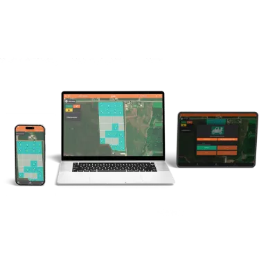
Radicle App allows you to create sampling maps and track field status in real time. It's your all-in-one package to save time and improve data sharing between your office, fields, and lab, giving you full control of your soil analysis process.
Your play-by-play, from start to finish
Radicle App puts you in charge of your entire soil analysis process. From when you import field boundaries to when you export final results, you have full control and visibility over every step.
Create Map
Field boundaries can be drawn, imported, or driven. From there, sample grids are created within seconds. Also compatible with polygon zones.
Start Sampling
Radicle app works with GeoPress to label and geo-reference soil samples, while saving that information to the cloud.
Get Results
Results automatically stream back onto the map directly from the lab and can be shared or exported from there.
Live sampling location radar
Samplers can see each other’s progress in the same field to improve communication & efficiency.
Color-coded field maps
Field boundary colors give a quick high-level view of whether a field has been sampled or analyzed to help with workflow & logistics.
Offline & no-service support
No cell service? No problem. Radicle app allows you to soil sample offline and stores data locally until connection is restored.