
- Home
- Companies
- Raptor Maps, Inc.
- Software
- Raptor Maps - Version Digital Twin - ...
Raptor Maps - Version Digital Twin -Solar Management Platform
- All of your performance-related data inputs exist in different platforms, whether that’s your inverter yield data, your equipment maintenance history, or your financial data.
- Your equipment inspections are delivered through static PDFs, which your on-site teams are printing out to find the issues to remediate.
- You spend a significant amount of time gathering data for reporting or putting together documentation for critical workflows such as warranty claims.
- We create highly granular digital representations of your assets, marrying both geospatial and temporal data. Equipment issues, power production, and more are localized to specific, geo-tagged locations so you don’t need to double guess which equipment needs to be replaced.
- Access your digital solar sites with an easy-to-use mobile app, providing you precise GPS locations to help you navigate to the issues needing remediation. Your digital twins are the link between the office and the field.
- A robust system of record streamlines your reporting needs and enables our productivity solutions to automate historically painful processes, freeing up your time to focus on high-value activities.
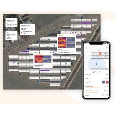
Standardize, normalize, and synthesize data for your sites in one place, delivered through an intuitive and interactive interface. Capture and geo-tag critical data such as serial numbers, equipment maintenance history, field notes, and more. Digitize all of your previous and current PV inspections for a holistic history of your asset health. Integrate data captured from your DAS/SCADA systems and on-site sensors to gain 360 degree visibility into asset performance.
Take your digital twins into the field, providing your on-site teams with unparalleled visibility and navigation to help them locate, navigate to, and remediate equipment issues. Available in offline mode, arm your field teams with the tools they need to get your power production back on track quickly and safely.
A singular source of truth integrating data across platforms unlocks smarter, more data-driven workflows and automation of manual tasks. From more robust root cause analysis to auto-generated claims packages, your digital twins can supercharge your operations and uncover previously unknown asset optimization opportunities. Increase both the velocity and confidence of decision-making.
Full record of your site
Compare data over time to identify trends. Combine insights from your DAS / SCADA system with recent aerial inspections to get a holistic picture of your asset’s health.
API-enabled
Integrate seamlessly with existing tools using our API, data exports, and more.
Seamless link between mobile and desktop
Capture imagery and notes directly from the field, accessible via the digital twin on your desktop