Remsoft
  1. Companies
  2. Remsoft
  3. Software
  4. Remsoft - Version Prism - Advanced ...

RemsoftVersion Prism -Advanced Forest Inventory and Data Management Software

SHARE

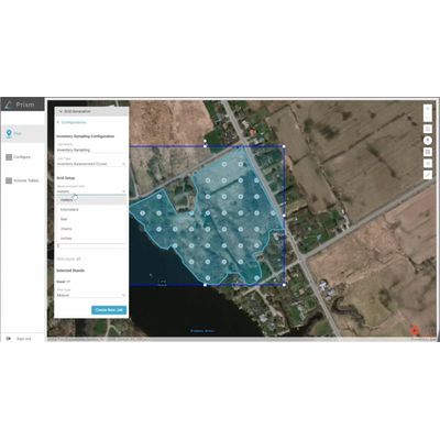
Prism by Remsoft is a sophisticated platform designed for comprehensive data collection, analysis, and reporting specific to forest inventory management. It operates seamlessly on multiple devices, including iOS, Android, and Windows tablets, offering flexibility and streamlined logistics. The system eliminates traditional paper-based data errors by digitizing inventory data processes, ensuring accuracy through pre-configured options and built-in validation tools. Prism supports real-time progress tracking and data sharing, enhancing field operations with mobile navigation and note-taking capabilities. It integrates easily with ArcGIS Online, providing robust options for inventory views in both web and third-party dashboards. The platform allows for customizable data capture forms to align with project-specific methodologies, enabling sustainable forest management and optimized decision-making. Prism also supports high precision GPS devices, ensuring data reliability and consistency for forestry products companies and consultants.

Most popular related searches

Prism is a one-stop solution for planning, completing and analyzing inventory data collection projects built on Esri ArcGIS technology.

Modern, scalable and super configurable data collection

From boots-on-the-ground to data in the cloud, Prism is a one-stop solution for planning, completing and analyzing inventory data collection projects (e.g., timber cruises, survival surveys, regen surveys, wildlife or wetland assessments, etc.). Prism replaces paper tally cards and USB sticks, ensuring error-free data and a single, up-to-date source of inventory data for reporting information.

Increased Accuracy and Efficiency
Eliminates paper and USB errors, streamlining data collection processes.

Up-to-Date Data
Provides a single, always-current source for inventory data reporting.

Customizable Data Collection
Tailors forms and setups to specific project needs and methods for any forest region.

Enhanced Field Operations
Mobile app improves navigation, data collection, and note-taking.

Robust Data Analysis and Reporting
Simplifies analysis and reporting with adaptive tools.

Versatile Data Viewing
Allows data viewing in web app or third-party dashboards, such as ArcGIS Dashboards.

Customize Jobs and Reuse as Templates

  • Localize tree species lists and specifications for target forest regions.
  • Configure data collection forms and inventory sampling protocols.
  • Define units of measurement and DBH or height classifications.
  • Create pre-canned species lists to standardize species names and codes.

Create Plots for any Cruise Type

  • Create 1,000s of plots in seconds or import plots from other apps.
  • Multiple plot types in the same job (e.g., variable radius vs. fixed radius or BAF10 vs. BAF20).
  • Configure double nested plots and subplots.
  • Accommodates any cruise type; timber, carbon, stump, or audit cruising, regeneration surveys, planting and survival surveys, ecological assessments, etc.

In-field Data Collection Validation

  • Configure thresholds for maximum and minimum numeric values (e.g., DBH or height).
  • Make fields required to reduce risk of data gaps.
  • Pop-ups to notify user of erroneous data entries.
  • Enable/disable field visibility and editability.
  • Two-way synchronization with built-in rules to prevent data duplication and maintain tree numbers.

Offline Navigation and GeoNotes

  • Navigation lines with azimuth and distance to target plot.
  • Configurable plot proximity and plot center audible and visual notifications.
  • Automatic plot enter and exit times for accountability and inventory dates.
  • Connect to Bluetooth GNSS high precision GPS (e.g., EOS Arrow 100).
  • Record GeoNotes points, lines, and polygons.

Equation Builder and Volume Tables

  • Configurable equation builder for biometric equations such as taper, volume, growth and yield, etc. – Create equations and view their results at multiple survey levels: trees, plots, stands, and jobs.
  • Leverage existing volume table CSVs and equations.
  • Equation tagging for searching and filtering.

Configurable Inventory Reports

  • Create and save report templates for different use cases (e.g., regeneration surveys vs. timber cruising).
  • Run reports based on spatial locations, such as working areas, properties, or tracts.
  • Create roll-ups based on user-defined criteria (e.g., DBH classifications, species groups, products, etc.).
  • Export reports as a CSV in other apps.
  • Use the Prism inventory database feature service in ArcGIS Dashboards and/or PowerBI.
Customizable and Re-Usable Templates

Custom-design your cruise criteria to target the data you need and save time by re-using collection templates for future jobs.

Daily Progress Monitoring

Track job progress on a user-friendly dashboard that updates plot status and surveyor productivity daily.

Targeted Inventory Reports

Know exactly what’s in your forest for sustainable management and optimized decision-making. Convert cruise data to targeted inventory reports that are easy to roll up, summarize, and export.

Device Compatibility
Access cruise details and complete tasks from your cell phone or Android, Windows, or iOS tablet with no tally cards or USB sticks required.

Navigation and Note Sharing
Navigate confidently with plot distance information and proximity notifications. Use the GeoNotes feature to share information about areas of concern or features of interest.

Accurate Data Collection
Know you’re collecting accurate and relevant data thanks to pre-configured options and built-in data validation