Remsoft
  1. Companies
  2. Remsoft
  3. Software
  4. Remsoft - Version Stratus - End-to-End ...

RemsoftVersion Stratus -End-to-End Forest Management & Data Analytics Platform

SHARE

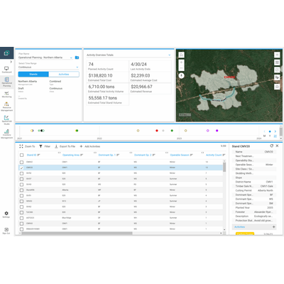
Stratus is a comprehensive SaaS platform focused on end-to-end forest management and data analytics. Built on Esri ArcGIS technology, it serves to streamline forestry operations across the lifecycle and timber supply chain by integrating planning, budgeting, and monitoring capabilities. It supports a variety of functions including silviculture, harvest, and construction operation management, while providing real-time access to data, whether in the office or in the field. Its GIS resources facilitate strategic resource deployment and advanced inventory control, enhancing data-driven decision-making. Stratus addresses the need for operational planning, spatial GIS management, and inventory management in forest management practices, benefiting forest products companies and management consultants by offering a common operating picture and situational awareness. Although it does not replace full-fledged GIS software, it is highly configurable to meet user needs, allowing seamless integration with existing systems for optimal forestry management.

Most popular related searches

Stratus is a comprehensive SaaS solution that consolidates all forestry life cycle and timber supply chain activities. Built on Esri ArcGIS technology, Stratus leverages existing GIS resources and offers tools for planning, budgeting, monitoring, and data-driven forest management.

A modern, secure, fast and easy-to-use forestry platform

Gain a bird’s-eye view of your forest with Stratus, a one-stop solution to consolidate your company’s forestry life cycle and timber supply chain activities—from start to finish.
Comprehensive Forest Management

Stratus integrates all forestry life cycle and timber supply chain activities into one platform, streamlining your operations from start to finish.

Enhanced Operational Planning

Plan, budget, and monitor silviculture, harvest, and construction operations with ease, ensuring efficient resource allocation and execution.

Real-time Data Access

Access and update data from anywhere, whether in the office or the field, ensuring your team is always informed and coordinated.

Strategic Resource Deployment

Deploy machinery and schedule operators strategically to maximize productivity and minimize downtime.

Advanced Inventory Control

Keep track of your inventory in real-time, always knowing what you have, how much, and where, to make informed decisions.

Data-driven Decision Making

Utilize integrated GIS resources and identify data trends to boost productivity, reduce costs, and optimize forest management practices.

Operational Planning

  • Plan harvest, silviculture, and construction activities.
  • Assign and edit activity attributes such as estimated start/end dates, cost, and revenue.
  • Divide activities into phases.
  • Compare scenarios to ensure business needs will be met for the target area.
  • See a timeline of planned, in-progress, and completed activities.

Monitoring

  • Monitor, calculate, and summarize KPIs.
  • See an overview of activity progress, volume harvested, cost, and revenue.
  • Auto-create follow-up activities based on criteria defined by your regime or sequence.
  • Create and update Stratus data in field via ArcGIS Field Maps or Survey123)

Resource Management

  • Schedule contractors, activities, tools, and equipment.
  • Assign resources to activities.
  • View timelines and schedules.

Spatial GIS Management

  • Import shapefiles of points, lines, or polygons – Create features and edit attributes.
  • Edit ancillary layers: e.g., merge, split, island, reshape, and buffer.
  • Web-based topological editing to ensure contiguous features.
  • Leverage edit session tools to keep track of and review edits before committing them.

Inventory Management

  • Import inventory information from a cruise, audit, growth and yield, or depletion.
  • Import inventory data as a CSV.
  • Integrate data from other applications, such as Prism and Field Maps.
  • Import inventory information from a cruise, audit, growth and yield, depletion, or any other inventory event (e.g., carbon cruise or enhanced forest inventory plot).
  • Import inventory from Prism or CSV.

Data Analytics

  • Graphs for activity distribution.
  • Overviews, summaries and dashboards.
  • Cost, volume and revenue reports.
  • Self-configured views.
  • Connect Stratus data to external applications for data processing or reporting.

Configurable

  • Choose preferred terminology and units of measurement.
  • Attach documents to operational units and activities.
  • Choose layers to display, and set their order, symbology, layers, and editability.
  • Configure user permissions and access to regional data (e.g., forest management unit) all directly in the application.
Common Operating Picture & Situational Awareness

Use a suite of tools to maintain full awareness of your operations, from big-picture data analysis and long-term reports to task-specific resource allocation and daily progress.

One Stop Shop

Stratus imports legacy data from other platforms and ensures streamlined data entry, resulting in a single, up-to-date information hub for all staff.

Easy to Use and Super Configurable

Stratus empowers users to set access permissions, configure settings, display data in map or table format, edit spatial layers, and more – so you aren’t relying on tech support.

Near Real-time Data

Sync, update, and access data from anywhere—even in the field.

Maximize Productivity
Make decisions, set priorities, and time operator activities confidently, knowing you’re working from the most up-to-date information.
 
Compliance

Maintain hassle-free compliance with environmental regulations and company processes.