
- Home
- Companies
- Scribble Maps
- Software
- Scribble Maps
Scribble Maps
Unleash your data and imagination with Scribble Maps. Build custom maps and identify insights across real estate, engineering, research, business, exploration, construction, manufacturing - and so much more.
It`s easy to build maps that transform your data into insights
Discover an easy way to visualize and make sense of your data.
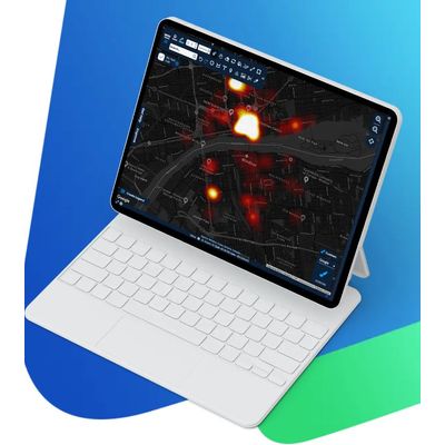
Scribble Maps can import any data that relates to a place and overlay it on a customizable map, ready for you to draw on, analyze, and discover insights.
- Import your data and get started
Get started by searching for Google Maps data, or copy your own from any spreadsheet, list, or geodata.
- Draw shapes to customize your map
Use your imagination and our tools to draw routes, trails, and boundaries that help you understand your data better
- Analyze your map and discover insights
Filter and visualize your data to identify research trends, data insights, and business opportunities
- Share your maps with anyone, securely
Protect your data with military-grade encryption, collaborate in the Cloud, and share your results
Search with Google maps data, or bring your own for analysis.
No matter which industry you work in, Scribble Maps can help you discover fresh insights and make better decisions.
Value any property or franchise more easily with an overview of every restaurant, bar, shop, school, hospital, and more.
View every nearby road, railway, and airport to identify connections for any property, business, or location.
Make better business decisions, with your sales performance, business metrics, and opportunities drawn on a map.
Visualize healthcare studies, disease outbreaks, and pathogen transmissions on a highly customizable and layered map.
Do deeper analysis, with social research, political trends, demographic data, and historical maps plotted or overlaid onto any map.
View boundaries for any province, political region, country, or state and overlay data for voting, spending, demographics, and more.
It`s easy to filter and visualize any commercial or research data, find better routes, and get valuable business insights.
Focus on the data that you care about with powerful data filters. You can combine queries to find the property, business deals, or research insights that you need.
Calculate the size of any area of land and determine its value, or the coverage required for concrete, solar panels, terraforming - and more.
Transform any data that relates to your sales, performance, or customers into heat maps for an easy strategy to find new business opportunities.
Optimize any route to save time, avoid obstacles, cut costs, visit more customers, deliver more items, and - ultimately - enjoy more revenue.
It`s fun and productive to build maps when you can collaborate together in real-time, and share the results in stunning detail.
Work faster and build better maps as a team in Scribble Maps, with support for multiple simultaneous users in each map.
Scribble Maps includes a dashboard and secure online portal, so you can share password-protected maps with colleagues.
Embed any map in your website, blog, or corporate portal - where it can be viewed and enjoyed by others.
Download any map as a high-resolution image, with no watermarked logo, ready to share or print.
Search for properties in any location and filter by price range, bedrooms, age, and features, then print. customized maps for clients.
Draw property boundaries accurately, then layer foundations, underground pipes, floors, and environmental factors.
Map-out each site and add any relevant operations, infrastructure, hazards, materials, and objectives in individual layers.
Visualize your team`s sales performance and customer data to identify potential untapped business opportunities.
Get a complete suite of technical and regularly-updated GIS tools, in an interface that`s intuitive and easy-to-use.
Transform social, geographic, historical, and scientific data into tangible maps that you can analyze for deeper insights.