
Simutech
Simutech - Version HIS-3D -Environmental Data Management Software
FromSimutech
Measurement data and station information: Recording, administrating, analyzing. The environmental data management system, the Hydrographical Information System, the database system for administrating and evaluating environmental data.
Most popular related searches
environmental data management
environmental data software
environmental data
environmental data management system
environmental data management software
data management software
environmental management
environmental software
hydrographic data
drinking water
Data Sources
- from highly frequent data series of one parameter (quantity) up to singular environment reports of some hundred parameters (quality)
- online measurement, data collectors, digitised data values, files in different formats
- e.g. water stage and flow, chemical, biological values, meteorology, profiles (geodesy), etc.
Measurement Station Information
- stored in the database with timing information
- e.g. station name, coordinates, contact person, as well as public orders, maps, plans
User Access Rights
- in several privilege steps
- saves data before unwanted access
- protects from unintentional data changes
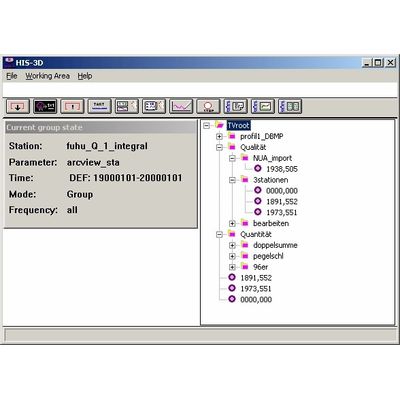
Data Access
- using thegroup system SPT: station, parameter, time
- cycle time: presentation and evaluation
- are independent from the data sampling interval
- easy access to data values
- presentation in dialogue boxes
- exportable to formatted lists
Editing
- numerical and graphical
- data series: move, turning around a point, copying, adding of values by interpolation and regression with stations in the neighbourhood
- protocol of changes (who/when/why)
Import/Export Of Data Values
- freely formatable; manual and automatic import
- is fault tolerant and learnable against wrong spelled words
- MS-Excel and ASCII tables with data values are simply dragged into the application
- automatic testing during import (e.g. plausibility) and export (e.g. cell formatting at values with boundary value violations, drinking water codex)
- XML for logically formatted exports
Graphics
- widely formatable, storable layout
- 2D-pictures (curve), 3D-surface
- colour intensity plots, isolines
Analysing Methods
- independent from samping interval (e.g. only 700 values)
- all results are output to a file, a graphic, or the database
- Script language (C) for criteria and analysis
- statistics (mean, sliding mean, minimum/maximum, variance, median)
- regression (over time and data series), trend, histogram
- arbitrary algebraic combining of data series (movable over time)
- double sum, flow-duration curve
- polygonalisation (data reduction)
- method and plausibility check
The System Environement
- User Desktop
- The client is available for different operating systems, like MS-Windows (drag-and-drop, clipboard, DDE, OLE, context help).
- adaptable to the user`s needs
- Database
- runs on a server or on the same single workstation
- e.g. Oracle or MS-Access
HIS`3D® is an open system
- expandable by new methods
- extendable by new data sources and parameters
- open to other packages, e.g.: MS-Excel, MS-Word, ArcInfo, ArcView
- operating system (MS-Windows NT/2000, Linux, Unix) and database independent