

TENEVIA FlowSnap® enables videos or continuous images to be used to measure free surface flow (rivers, streams, wadis, canals, etc.). A contactless (non-intrusive) measuring instrument, FlowSnap is designed to take on-site measurements of surface velocity and discharge quite safely. This measurement system can be implemented quite independently and without any prior installation, using a conventional image-taking device (camera, smart phone, etc.) or one recommended by TENEVIA.
Field hydrometrists, study managers, river technicians, technical departments or volunteer service members, get this new tool to enhance your on-site interventions.
A complete measuring experience
FlowSnap is hydrometry software designed for an optimum on-site experience. The user experience proposed includes a tested field protocol and a selection of adapted equipment.
For optimum implementation of the FlowSnap system, TENEVIA has created a fun training course that combines the practical and theoretical aspects. Training sessions are regularly organised in our offices near Grenoble or at a client site on request.
Intuitive and convivial software
The FlowSnap software has a number of functions designed to facilitate processing and optimise the extraction of the hydrometric information. You do not have to become an image processing specialist to use this video hydrometry system. The software also enables the extraction of data to other software programs. The different processing stages are clearly presented and benefit from functions that make it easy to navigate in the images.
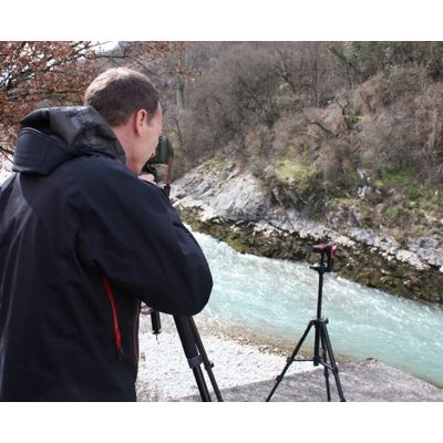
Rapid and safe deployment
Based on the acquisition of videos or series of images, the taking of on-site images allows measurements to be taken on a number of sites during the same hydrological phenomena. The site calibration protocol is in fact separate from the measurement. On site, the data collection that allows the measurement to be taken is simply video acquisition.
The FlowSnap approach allows measurements to be taken without any contact with the water, at a reasonable distance from the river. The solution also allows considerable flexibility in the choice of shooting location, which can be on a bank or a bridge. The presence of a structure that crosses the river is therefore not necessary.
Spatialised velocity measurements
FlowSnap’s operation is based on the spatialization of surface velocity. “Velocity vector” fields can then be measured for the whole of the flow section. The hydrometrist can therefore choose the section on which the cross-section surface velocity profile is developed.
Organising and managing series of surface gauging
The FlowSnap software allows different sites to be created. Several calibrations and series of measurements per site can therefore be archived. The organisation of this is directly managed by the software in the form of a user workspace. This workspace also facilitates inter-user data exchange.
An enhanced hydrometric assessment
The FlowSnap software allows the user to control all the measurement steps and parameters. His knowledge of the site and expertise in hydrometry can in fact be exercised within the tool.
The principle of gauging through image analysis proposed by FlowSnap is based on identifying movements on the water’s surface like, for example, small floating elements (branches, leaves, bubbles, etc.) or structural movements of the water.
To obtain flow velocity measurements on the user’s selected section, the system is implemented in two steps:
- Calibration: This step can be carried out just once, either before or after acquiring a measurement video.
- Measurement: Acquisition and processing of video sequences taken from a nearby location to the one chosen for the calibration.
This step consists of matching points whose topographic coordinates have been surveyed in the field with their position in a calibration image. These points can be fixed markers and temporary markers, only materialised during the calibration process. The recommended equipment for this step is the Leica S910 laser distance meter available in the FlowSnap equipment section. This calibration allows to convert the measured velocities in pixels per second in a metric unit (or Anglo-Saxon) whatever the water level is.
Once the image is in a 3D reference frame (X, Y, Z coordinates), it is necessary to set up a transverse profile to obtain flow information. The interface of the software allows a simple fusion of topographic and bathymetric data.
In addition, the software offers the possibility to visualise in 2D the horizontal and vertical interactions with the different calibration points.
The action of taking images consists of taking one or several videos or sequences of images (Time Lapse) of the river that correspond to the moment when the measurements are required.
Images must be taken by a device installed on a base so that the video or sequence of images is not corrupted by the device moving.
The image-taking therefore corresponds to the “field part” of a series of stream gauging in FlowSnap.
The measurement is done by processing the images in the FlowSnap 2 software. Once all the videos or image sequences have been taken on site, there are only a few steps to obtain flow information.
- Upload the images or video (image extraction)
- Choice of calibration
- Specifying the height of the water body at the time of image capture.
- Recalibration between the measurement images and the calibration image
- Processing the velocities on the selected image pairs
- Calculation of the flow rate
The processing of the velocities (5) can be carried out automatically by the software and manually by the user. This treatment makes it possible to obtain a very great number of velocity vectors on the section (several hundreds to several thousands), visually controllable on a “result image”. The design of the software also favours the archiving and management of the various measurement campaigns carried out on the same site, thus making it possible to constitute a measurement history for the development of a rating curve.
TRAINING OBJECTIVES
The aim of this training is to present the general principles that allow the transfer from the image (information in pixels) to a real value (metric information), using measurements taken on the site. The training also aims at giving user guidelines in order to take usable pictures and thereby ensure greater precision. The training is for professionals or those who use river measurements, without any particular prerequisites.
PROGRAM
- Introduction to the technique of image analysis (indoors) [theory]
- On-site session and using the recommended equipment [remote assistance on a first site]
- Presentation of TENEVIA’s FlowSnap® software [using the software]