

- Home
- Companies
- GIS Cloud Ltd
- Software
- GIS Cloud - Solution for Field Data ...
GIS Cloud - Solution for Field Data Collection
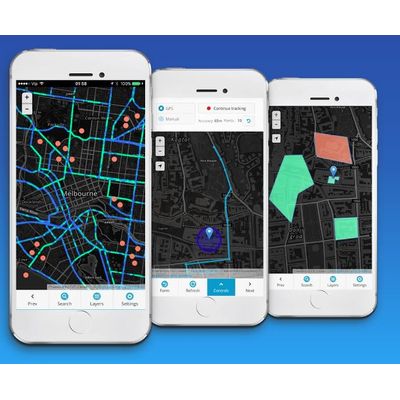
Transform your workflow from paper to digital. Complete solution for field data collection; Collect and inspect POINTS, LINES and POLYGONS with a single app. Carry out your entire project from start to finish and report to stakeholders using one solution, without worrying about piles of paperwork.
Fast and easy deploy
Most of our users set-up their surveys and train the staff in less than a day.
Collect different types of assets
Choose between point, line or polygon project to collect different geometry in the field.
Work online or offline
Download offline maps to access data even without network coverage.
Automatic (GPS) or manual collection
Capture data location with GPS, or use a pinpoint tool to manually add points and draw lines.
Data quality control
Use form item options like dependencies, required fields, radio buttons and others, to capture complete and accurate data. No coding required.
Cost effective
Scale up and down according to your project size and timeframe.
Easy to learn tools eliminate time and money usually spent on training.
- Create a survey directly in your browser and access on your phone
- Choose point, line, or polygon project and customize your form fields (text, number, select list, photo, electronic signature…)
- Make your fields dependent, required, persistent or use other form field options to enable fast and accurate data collection
- Preview your form before you share it
- Include photos, audio, QR codes, barcodes and more
- Deploy survey to mobile users by sharing a form
- Share with a team member or a whole group
- You control who can collect or update data
- Manage team roles (project manager, field crew, analyst, stakeholder…) using permissions
- Update form changes on the go (automatic sync across devices and users)
- Collect, inspect or update data in the field using Android or iOS mobile app
- Use "Navigate to feature" option to find assets in the field
- Fill in your survey, walk or drive while data is collected automatically - drawing points, lines and polygons
- Review and edit data attributes directly from the field
- Access your maps and data anytime, anywhere
- Work in offline mode - data is stored on your device and synced to cloud when online again
- Use Mapbox, Open Street Map, Bing or custom basemaps
- Review collected data in real time and monitor projects
- Update form changes on the go (Automatic Sync across devices and users)
- Manage teams and jobs, assign tasks and make decisions
- Generate reports and export data for stakeholders and funds