

- Home
- Companies
- Black Laser Learning, Inc.
- Software
- Sar Hawk Humminbird - Sonar Target ...
Sar Hawk Humminbird - Sonar Target Acquisition Software
SAR HAWK® software elevates an economical Humminbird® sonar to a professional target acquisition and mapping tool. SAR HAWK® software was designed with the Search & Rescue professional in mind. Just plug the SD card into your computer to review Humminbird® data at full resolution and use the advanced analysis tools to find targets, check for full coverage and generate reports. It is highly automated, easy to use and ideal for either occasional or daily missions.
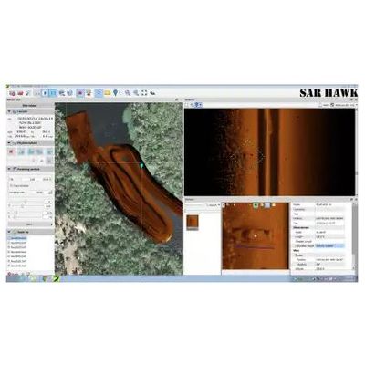
Marking and examining targets on the fly under field conditions does not always provide the best opportunity to locate difficult targets such as drowning victims. No search is complete until the data has been reviewed onshore under controlled conditions. SAR HAWK® allows the operator to scroll through data on a large screen for maximum resolution to easily identify targets.
SAR HAWK® software provides the user with the ability to mark and measure targets while also highlighting every instance your sonar passed the contact. When a target is marked, SAR HAWK® automatically assigns a target number and generates a contact snippet with coordinates. Each contact can be renamed, measured and annotated. Have a tricky target on a cluttered bottom with multiple passes and finding it hard to identify the target on each pass? No problem with SAR HAWK®. Every view of each contact is outlined with a dashed square. You’ll always know you’re looking at the same target on every pass. Contacts are easy to export for smooth hand off to diver or ROV recovery teams.
Need a coverage map for your report? No problem. SAR HAWK® automatically creates coverage maps superimposed over local satellite imagery when connected to the internet. In the map view, each contact is geographically located and denoted by an icon superimposed over the sonar mosaic. The coverage map allows for full resolution zooming so targets can be examined in the context of their surroundings. The sonar mosaic can be optimized by clipping out the turns and choosing which sonar images are displayed.
- Built specifically for the Search & Rescue community
- Highly automated – Easy to use
- Facilitate target analysis, tracking and reporting
- Detect gaps in coverage
- Include sonar snippets in contact reports
- Automatically create sonar mosaics and bring in appropriate background imagery (need internet connection)
- Get depth data
- Remove turns and watercolumn from sonar mosaic
- Smooth position, heading and altitude for better navigation
- Export results to a variety of formats or right to Google Earth
- Use with Humminbird® HELIX®, HELIX ®MEGA, SOLIX® and 800 through 1100 series data formats
- Proudly created in the USA
- For capability to export xyz data, check out SAR HAWK® Surveyor