
TerraMath - 3D Geological Modelling Software
Our software allows to use all common geological data sources as input: Field measurements (strike/dip). Well logs. Profiles (which can be digitized using WinGeol). Point measurements. Triangulated faults (designed & created in WinGeol).
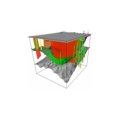
The result of the 3D interpolation which honours trend data and faults is a VOXEL model of user defined resolution. Such models can be easily to converted to be used in numeric groundwater or geothermal simulations. Typical information stored by cell / VOXEL are rheology, orientation and estimated quality of interpolation.
An advantage of the VOXEL approach is the higher stability of the algorithm in comparison to complex surface / solid based approaches which may fail already on tiny geometric errors, which are extremely time consuming to remove and hard to avoid using real world data.