
TOPOWIN - Version 23.02 -Topographic and Cartographic Information Register Software
TOPOWIN is a topographic information system and country-wide register of the German Topographic Cartographies, the German Basic Cartography and of localities with georeferences in different Coordinate Systems.
TOPOWIN - Version 23.02 - Last update on 30 January 2024
The latest important changes
- All data applied updated to the data status January 1, 2024.
- Certification of the program and the installer renewed.
- Program is faster and more stable using a new development system.
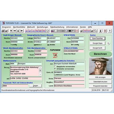
- View of maps in OpenTopoMap, Google Maps, Google Earth.
- All map views supplemented with UTM edge coordinates.
Register of the German Topographic Cartographies
In the context of the planning and execution of economic and scientific projects, topographical documents are often used. The program TOPOWIN provides information of the Official Topographic Map series and the German Basic Map series from the entire national territory in suitable graphic views. It performs various coordinate transformations and researches. The program has been developed with the participation of many Federal State surveying authorities. For the first time in the previous version TOPO (for DOS) and later in TOPOWIN nationwide topographic information has been compiled for data technical evaluation. The program is a useful and versatile tool for engineering offices, planning offices and users of topographic maps.
The topographical maps of different standards, required for a project, can be determined by the complaint of known parameters or by the direct selection from overview graphics and from sorted lists. By the investigation of topographical records on the basis of known places, a data base with more then 125.000 localities and residential districts is available.
The program TOPOWIN calculates with Gauss Krueger coordinates and Geographic Coordinates referring to the Potsdam Datum (Bessel ellipsoid with central point Rauenberg). It also works with UTM coordinates and UTMRef coordinates in the NATO standard, which refer to the datum ETRS89 (GRS80 / WGS84, geocentric). A special feature of the program is the determination of the map sheet corners in UTM / ETRS89 coordinates.
To search for maps and to calculate map parameters, the parameters listed here can be entered directly in the input fields of the program:
- Gauss-Kruger coordinates (also from the "wrong" meridian strip)
- Geographical coordinates in gradual notation
- Geographical coordinates in decimal notation
- UTM coordinates
- Place names or quater names
- Municipality ID (8-digit municipality key)
- Map number of a Ordinance Survey Map TK25
- Map name of a Ordinance Survey Map TK25
For selection from separate windows are available:
- Nationwide graphical overview map to select a TK25
- List with numbers and names of the TK25 sorted by Federal States
- List with numbers and names of the TK25 sorted by Administrative Regions
- List with numbers and names of the TK25 sorted by Rural Districts
- List of place names and quarter names sorted by Federal States
- LList of place names and quarter names sorted by Administrative Regions
- List of place names and quarter names sorted by Rural Districts
After entering a value or the selection from the overview or a list, the program calculates the values listed here and carries out corresponding coordinate transformations:
- Gauss Kruger coordinates
- Gauss Kruger coordinates, based on the western neighbor meridian strip
- Gauss Kruger coordinates, based on the eastern neighbor meridian strip
- Geographical coordinates in gradual notation
- Geographical coordinates in decimal notation
- UTM coordinates
- UTMREF Military Grid Reference System (NATO notation)
- Map number of the matching TK25
- Map name of the matching TK25
- Corner coordinates of up to four matching TK25
- Map number of the matching TK50, TK100 and TKü200
- Reference address of the competent Land Survey Office
- Main town on the map
- Place center coordinates
- Municipality ID (8-digit municipality key)
- Rural districts of the place
- Administrative region of the place
- Federal State of the map and the place
After entering the following information are available graphically prepared on separate windows. In all views, the current location is entered.
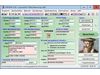
- Data window with map information and converted coordinates
- Data window with the data of up to four maps matching the coordinates
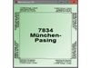
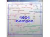
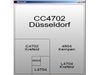
- Ordinance Survey Map TK25 with map name, map number and corner coordinates
- Overview of up to four possible Ordinance Survey Maps
- Current Ordinance Survey Map with the eight adjacent Ordinance Survey Maps
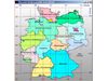
- Location of the Ordinance Survey Map in the national overview
- Location and name of the places on the Ordinance Survey Map
- Location and designation of the German Base Maps on the Ordinance Survey Map
- Location and designation of the TK50, TK100 and TKü200 and the Ordinance Survey Map
- Corner coordinates of the TK50, TK100 and TKü200 and the Ordinance Survey Map
- Reference addresses of the competent Land Survey Offices
Other possibilities offered by the program:
- Printing of the current map parameters and sources of supply
- Printing an order list
- Printing the graphic representations
- High precision coordinate transformations
- Determining the center coordinates of localities (georeferencing)
- Assignment of maps to the political units Federal State, Administrative Region and Rural District
- Assignment of places and quaters to the political units Federal State, Administrative Region and Rural District
- Determination of the most important location on the map
- Determination of the 8-digit municipality key of localities
- Edit control files in ASCII format for coordinate transformation and map parameter determination
- Generating lists with the corner coordinates of the TK25, TK50, TK100 and TKÜ200 in different coordinate systems
- At any time case-related help from an electronic manual
- etc.