

- Home
- Companies
- 4M Analytics
- Software
- 4M - Utility Mapping Solution
4M - Utility Mapping Solution
Constructing the confidence you need to build tomorrow’s infrastructure. Picture this: a comprehensive, reliable, up-to-date GIS map of utilities above and below your site. Your key to planning, engineering, and building tomorrow’s infrastructure, using a 21st-century tool that’s really made for the job.
No more spending months searching for as-builts, weeks waiting for locating results, days converting lines from one software to another. No more rifling through paper as-builts, no more chasing the data you need through dozens of different agency websites. No more living with unquantified risks, sky-high contingencies, and razor-thin profit margins.
Finally, a technology that will change the way you feel about infrastructure - the way you visualize, coordinate, design, and work around the utility lines that allow our cities and communities to thrive.
Get utility data upfront to plan your project and budget and schedule from the earliest phase.
Avoid utility conflicts, prevent accidental damages, and protect your bottom line.
Manage assets with a digital map interface tailored to your project needs.
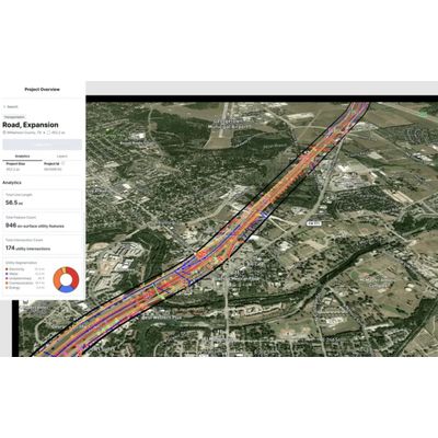
4M is building a full-coverage, nationwide utility map based on satellite imagery, computer vision, and comprehensive record search.
Assess site conditions, allocate resources, and manage contingency using a “bird’s eye view” of current and future projects.
Identify undocumented or undetected utilities, lead field investigations, and validate as-builts using the latest map data, combined from multiple records and aerial imagery.
Minimize utility conflicts, reduce liability through due diligence, and enable your team to operate safely and strategically.