

- Home
- Companies
- 4M Analytics
- Software
- 4M - Utility Verification (QA) Solution
4M - Utility Verification (QA) Solution
Construct confidence and perform due diligence with utility mapping. Most projects include a variety of utility locating processes by different stakeholders throughout the project timeline. Utility verification or quality assurance is a way to ensure that utility information derived from different sources is accurate, consistent, and comprehensive.
Every form of utility designating and locating has advantages and drawbacks, but adding another technique helps you construct confidence.
As-builts and other utility records may not be properly geo-referenced or contain significant inaccuracies or deviations from real installations.
Aboveground surveys can miss key information that reveals previous installations of utilities below ground.
Utility designating through geophysics methods may be conducted or interpreted incorrectly for the soil conditions and the material and energy properties of the various utilities.
Utility locating through exposure is limited to the specific points where it is carried out and restricted by accessibility, cost, and time implications.
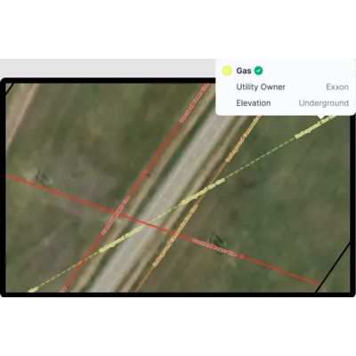
4M verifies utilities and performs QA using satellite imagery and computer vision to gather comprehensive data.
4M supports stakeholders by conducting QA for boots-on-the-ground utility location services. In particular, 4M adds value to SUE surveys by providing comparative results through remote sensing technologies.
4M offers stakeholders a map of the site with broad context and precise georeferenced findings. These results can be used to validate existing knowledge of utilities, as well as correct deviations on linear paths and add missing information.
When the utility is abandoned, inactive, nonconductive, or uninsulated, it may be difficult to detect with boots-on-the-ground teams, even with the latest geophysics technology. But 4M provides a new tool to the arsenal by finding visual evidence for abandoned lines by analyzing satellite and aerial imagery.