

V-G - Version GT Map AR/VR -Remote Collaboration Support Software
Remote collaboration support system to manage 5G-based underground facilities. Introducing GT Map AR/VR.
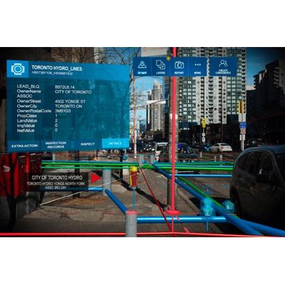
3D Visualization
Visualize in 3D for facilities buried underground
7 major underground facilities related to water supply, sewerage, electricity, gas, communication, oil transmission, and heating are viewed and checked in 3D through extended reality technology.
Remote collaboration
Identify the situation on the spot and act quickly.
When an underground facility-related accident occurs, the person in charge who visited the site and the manager of the office share the same screen. See the same screen, quickly grasp the situation, and take instructions and actions.
Data validation
Compare reality and data through smart glasses or a tablet. If there is a discrepancy from reality, make changes and apply them on the spot to update your data.
Compare reality and data through smart glasses or a tablet. If there is a discrepancy from reality, make changes and apply them on the spot to update your data.