

VertiGIS ConnectMaster - Network Modelling Platform Software
Comprehensive features for modelling the layer structure of telecommunications networks. State-of-the-art geographic mapping of networks with Esri’s ArcGIS®, extended by tabular and schematic viewing, editing and reporting.
Telecommunications Data Model
Modelling of the physical and logical layers of your network in one platform.
Geographic Network Mapping
State-of-the-Art Geo-Mapping and easy integration with ArcGIS® environments
Scalability
From small to extra large – scale your VertiGIS ConnectMaster solution to meet your needs.
Telecommunications Data Model
Create component types for passive and active equipment used in your telecommunications network. Create the topology of each network layer you want to document and model the connectivity within a layer and between layers based on predefined rules.
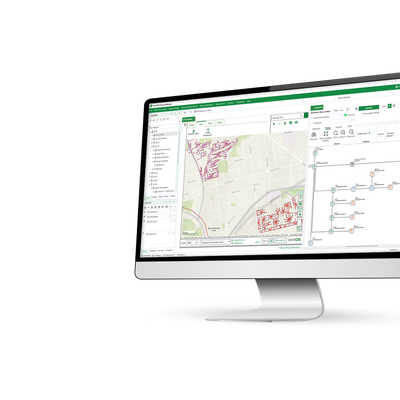
Network Mapping
Visualize your network layers with high-end tools for geographic and schematic mapping to best support your engineers during the planning, building and operating stages of your network projects.
Benefit from integration with ArcGIS® environments through resource optimization and enhanced user productivity.
Scalability
VertiGIS ConnectMaster is a platform offering comprehensive feature sets, configuration and integration options. Scale depending on your needs and intended applications, from complex networks and big operations teams down to smaller installations – for best results at lower cost.