

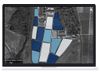
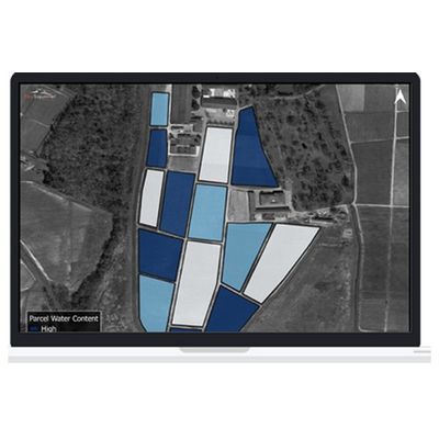
VineView - Water Index Crop Management Software
High Resolution Water Index mapping allows growers to target water applications and optimize irrigation management while conserving water and reducing a vineyard’s impact on the environment. While other water measurement methods are expensive, labour intensive, dependent on environmental factors, and susceptible to human error, VineView uses a spectral approach to directly quantify the water content of a vine. Our unique, non-destructive method provides a water index measurement for the entire vineyard with vine level detail, compared to a few data points throughout a parcel.
Make informed irrigation and cover crop management decisions while minimizing the ecological footprint of your vineyard.
Respond quickly
Our aerial-based system allows for speedy data collection, so you can address areas of concern quickly and efficiently.
Improve grape quality
Using accurate irrigation and cover crop data, growers can achieve optimal sugar and acidity levels.
Conserve water
Reduce your vineyard’s impact on the environment by directing water resources only where and when they are needed.
Reduce costs
Aerial water index data collection is significantly more cost effective than existing labour, time and cost-intensive water measurement systems.