


XPSTORM - Integrated 1D/2D Stormwater and Floodplain Model
When lives and property depend on the engineering decisions that you make, you want the data supporting your work to be reliable and easy to understand. You don’t want to risk taking shortcuts with insufficient calculations or make assumptions about system elements when you don’t have to.
xpstorm is a versatile software package for dynamic modeling of urban stormwater systems and river systems. It is used by scientists, engineers and managers to develop link-node (1D) and spatially distributed (2D) hydraulic models for analysis and design. Widely used by private consultants and public agencies responsible for stormwater and flooding regulation, xpstorm is one of the most stable and well-accepted modeling and design packages in the world.
xpstorm simulates natural rainfall-runoff processes and the hydraulic performance of drainage systems and floodplains. It allows integrated analysis of flow in engineered and natural systems including ponds, rivers, lakes, overland floodplains and interaction with groundwater.
Use xpstorm for fully integrated hydrologic and hydraulic stormwater modeling – from cloud to ocean! This comprehensive software program will allow you to Model With Confidence.
Integrated Stormwater Modelling - Combine comprehensive hydrology and hydraulics in the same model. Don’t jump between two or three different stormwater packages to build a complete stormwater model. xpstorm offers the tools to perform fully integrated system modelling, from rainfall to channels, pipes, streets, inlets, ponds, weirs, pumps, catchments, groundwater table, overland floodplains, rain gardens, infiltration trenches and more.
Localisation. Your hydrology, your way. With over 23 hydrologic methods available and numerous ways to input real or synthetic rainfall data, xpstorm allows you to model the appropriate rainfall/runoff for your project in your region.
Accurate Simulation. You need a tool with model elements that accurately reflect the physical realities of your drainage systems. Fully linked 1D and 2D modelling with appropriate variables for every element allows you to see the true behaviour of stormwater flow in natural and engineered systems. Minimise the need for approximations and “modeling tricks” by using xpswmm.
Advanced Design. Automatically identify flow choke points and let xpstorm design solutions (pipe sizes, slopes). Use automated Detention Pond Optimisation methods to configure storage. Fully dynamic hydraulic analysis will allow you to complete LID design to maximise the technical solution at lower costs.
Easily Convey Results and Data. XP Solutions offers a unique free Reader of xpstorm models called xpviewer. Users encrypt models with this add-on module so that others can view an un-editable model. This is extremely helpful to consultants as they convey their modelling approach, and invaluable to reviewing authorities who want to see model details without investing in a full license.
Industry-renown Support. Nothing is worse than facing a deadline and wasting time trying to troubleshoot an error. xpstorm is supported by engineers who have used the software in the professional world. They understand your need for urgency and are driven to help you succeed.
xpstorm equips engineers with tools for accurate stormwater analysis and easy reporting:
- Review results in nearly any format, from text files and fully customisable xptables to animated profile, cross section and plan views.
- Compare results for various scenarios including 2D layers with the Scenario Manager
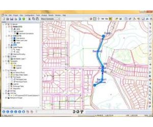
- GIS and CAD integration allows you to easily create models from external data. No need to own any other program to use xpstorm!
- Import from or export to SWMM5 model formats
- Simulate parallel flows - model street flow alongside underground systems and situations where flow is limited by inlet capacity
Special Applications
- Hydromodification
- Braided River Systems
- Evacuation Planning
- Assessment of Mine Site Development
- Sustainable Drainage Analysis (LID, WSUD, SuDS)
- National Pollutant Discharge Elimination System (NPDES)
- National Flood Insurance Program (NFIP)
Because you want to be confident that the models you create and submit for review are accurate and easily understood.
Integrated Stormwater Modelng. Combine comprehensive hydrology and hydraulics in the same model. Don’t jump between two or three different software packages to build a complete stormwater model. xpstorm offers the tools to perform fully integrated system modeling - channels, pipes, streets, inlets, ponds, weirs, pumps, catchments, groundwater table, overland floodplains, rain gardens, infiltration trenches, and more.
Model the Real World. You need a model that accurately reflects the physical realities of your drainage system. Fully linked 1D and 2D modeling allows you to see the true behavior of stormwater flow in natural and engineered systems. Minimize the need for approximations and “modeling tricks” by using xpstorm!
Advanced Design. Automatically identify flow choke points and let xpstorm design solutions (pipe sizes, slopes). Use automated Detention Pond Optimization methods to configure storage. Fully dynamic hydraulic analysis will allow you to complete LID/WSUD/SuDS design to maximize benefits at lower costs.
Industry-renown Support. Nothing is worse than facing a deadline and wasting time trying to troubleshoot an error. xpstorm is supported by engineers who have used the software in the professional world. They understand your need for urgency and are driven to help you succeed.

So much data, so little time. Save time building a model of your drainage system or watershed while taking advantage of all of your available data.
GIS Integration. Dynamically link to almost any external database to build your model and populate model parameter fields. Streamlined linkage to ESRI and MapInfo databases allows you to take advantage of the GIS data without the limitations and cost of using a GIS software license.
Import existing models and designs from HEC-RAS and MicroDrainage to save time in model creation.
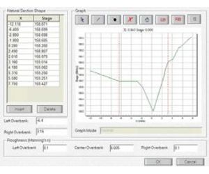
Digital Terrain Model. Create or import land surfaces in xpstorm to allow generation of cross sections of open channels, assignment of 1D node elevations, or computation of overland flow depths/directions (2D hydraulics).
CAD Integration. Use CAD files of preliminary designs for drainage system analysis. Work with data from any DXF, DWG, LandXML, or 12D file. No need to redraw data in xpstorm!
Reduce the risk of inaccurate results. Many software programs estimate flows, but only xpstorm runs the full dynamic calculations for overland and pipe/ channel flows.
Dynamic Analysis. xpstorm solves the full St. Venant dynamic flow equations. Dynamic modeling allows you to account for the effects of storage, flood backwater and hydrograph timing in your stormwater system.
Integrated 1D/2D Analysis. xpstorm can fully couple 1D network flow with 2D overland flow to accurately model interaction between flood waters and drainage systems, including underground pipes and natural channels. xp2D lets you model complex systems as they really are, wherever the water flows.
Stability. Power through complex analysis of varied flow regimes: sub-critical flow, super-critical flow, pressure flow in open channels, pipes, structures, and overland. Stability and accuracy of the xpstorm engine will allow you to spend your time in scenario generation and design rather than troubleshooting stubborn numerical problems.
You need to view and understand model output easily. Your reputation as a modeler depends on those results.
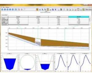
Full Results Output Document. This comprehensive text file allows you to review complete model data, computational details and complete results.
XP Tables. View and edit model input/output data in a user-customizeable spreadsheet environment. Profile/Cross Section Plots with Animation. View HGL, water surface elevation and data tables in a customizeable plot window.
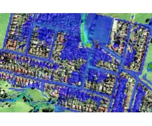
Flood Mapping. Create color-coded flood depth maps, floodplain boundary maps, flood hazard maps, and base flood elevation (BFE) contour maps.
Animations. Create/watch movies of flow progression over time. See it like it will happen in the real world.
How will a new design or a different flow input affect your system? Make sure your software program can allow you to rapidly assess your options!
Scenario Manager. Examine multiple “what if” scenarios within a single project with full tracking of changes. Run multiple storms automatically. Compare scenario results graphically and in tables.
Design Tools. Automatically identify flow choke points and let xpstorm design remediation (pipe sizes, slopes). Use automated Detention Pond Optimization methods to configure storage.
LID/SuDS/WSUD. Evaluate the impact of various configurations of green stormwater control schemes and water-sensitive urban design practices. Whether restoring an area to a more natural condition or minimizing the impact of new development, modeling the sustainability of a stormwater system will help you meet client’s and regulator’s environmental impact requirements.
Deliver your model to clients and/or regulators easily and with the confidence that they will see the value in your analysis or design.
xpviewer Encryptor and Free Reader. Your clients and regulators don’t have to own xpstorm to view and approve your model. Simply encrypt a model with the xpviewer module so that your clients can review it with the free reader software which includes all the powerful tools used to build, optimize, and visualize the model.
Model Export. xpstorm model data and results may be output to various formats that may be preferred for submission/review by your clients including GIS files, graphics, text or tabular data, maps and more.
EA Benchmark Tested, FEMA Approved. xpstorm is approved by the US Federal Emergency Management Agency (FEMA), meeting NFIP criteria for hydraulic or hydrologic projects (DFIRM, CLOMR, LOMR). xpstorm with xp2D were benchmark tested by the U.K. Environment Agency with excellent results. Countless other stormwater regulators are familiar with xpstorm and prefer modeling performed with its powerful tools.