

- Home
- Companies
- YellowScan
- Software
- YellowScan LiveStation - Real-time ...
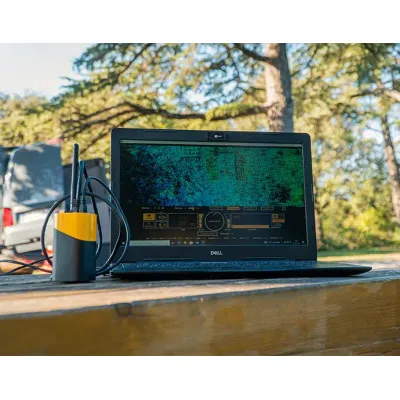
YellowScan LiveStation - Real-time LiDAR Monitoring
YellowScan LiveStation is an advanced in-flight monitoring solution designed specifically for challenging and extended LiDAR survey missions. It provides real-time validation and quality assessment of data collected by YellowScan LiDAR systems. With live 3D pointcloud visualization, system operators gain immediate insights into data acquisition, ensuring smooth operations even in complex environments. The interface allows for viewing, zooming, translating, and rotating the pointcloud during flights, offering a comprehensive look at terrain and other elements scanned by the LiDAR. Additionally, the transect view helps verify the LiDAR's ability to penetrate dense forest canopies and sample ground data effectively. Engineered by surveyors for surveyors, LiveStation stands out with its cutting-edge visualization tools and user-friendly interface, which concisely summarizes system status and enhances operational efficiency in real-time applications.
A must for long endurance or complex LiDAR flights
The YellowScan LiveStation enables you to monitor in real-time the validity and quality of the data being collected by YellowScan LiDAR systems.
Live 3D pointcloud visualization
The LiveStation provides system operators with the immediate and relevant information needed to ensure a smooth acquisition even in difficult working conditions.
View your LiDAR data in real time
The LiveStation provides a three-dimensional representation of the pointcloud during flight, with the ability to zoom, translate or rotate.
Cutting edge visualization design
The user interface gives you an immediate summary of the system’s status. The transect view easily allows the operator to check in real-time whether the LiDAR can penetrate a forest’s canopy and sample the ground.
- Live visualization
- Mission replay
- Navigation controls & status
- Viewer parameters