- Home
- Companies
- Geotomographie GmbH
- Applications
- Seismic borehole and surface solutions ...
Seismic borehole and surface solutions for cavity detection sector - Monitoring and Testing
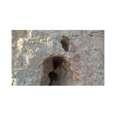
Karst structures: Solution processes are a common phenomenon in limestones and dolomites which can lead to karstification causing in many cases cavities. They can be air-filled or filled with fine-grained material, which decrease the soil stiffness and thus the load capacity. Exploratory drillings, which are generally used for soil investigations, provide only local information about the subsoil conditions and are not suitable to detect small-scaled structures in a geologically heterogeneous environment. Therefore, seismic methods are used for a detailed exploration of geological structures and cavities, whose elastic properties differ from the environment’s properties. In particular, seismic tomography which is carried out between two drillings, is well suited to characterize the location and dimensions of shallow and deep structures.
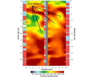
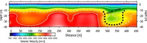
In the course of a new railway route seismic tomography was applied to investigate several bridge foundation sites to detect karstic structures and avoid settlements caused by dynamic loading of bridge piles. The tomogram shows the seismic velocity distribution representing the elastic material properties. Areas with low velocities (green) could be identified as karst structures while compact limestone shows significantly higher seismic velocities (red).
Weak zones in the subsurface are often caused by dissolution and washing out processes, weathering or geological faults. Weak zones lead to a reduction of the rock strength and have often an increased hydraulic permeability.Seismic methods are very sensitive to changes of rock strength and are well suited to explore weakened material or to investigate changed material properties of the subsurface.
Drillings can give only local information about underground conditions. But in a complex heterogeneous geological environment the exploration might fail structures, such as cavities. To carry out a comprehensive investigation geophysical methods such as gravimetry are successful to locate two-dimensional underground structures. Gravimetry measures local changes of gravity. Gravity anomalies occur when the density of the rock decreases due to voids and cavities and differ from the surrounding density.
Example:
In the area of a closed mining gravimetry measurements were conducted to identify and to localize potential cavities. The results show negative and positive gravity anomalies due to gravity changes. While the positive gravity anomalies (green) indicate compact rock, the negative gravity anomalies (red) are an evidence for the occurrence of cavities.
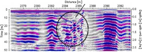
Washing out and solution processes or insufficient sediment consolidation can lead to sudden or long-term subsidence of the subsoil. Georadar is a suitable geophysical method to investigate the shallow surface up to several meters. The measurement principle is based on reflection of electromagnetic waves caused by interfaces or anomalies in the subsurface.
Example:
Cavities or settled areas in the subsurface cause increased reflection amplitudes and show typical reflection pattern in the radargram.