

- Home
- Companies
- EarthSoft, Inc
- Articles
EarthSoft, Inc articles
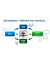
Who uses EQuIS™? The user base for EQuIS is large and varied, but generally can be divided into two different categories—power users and casual users. Power users are typically database administrators and scientists who setup, configure, and manage the system at a base level to enable use by all. Casual users are often project managers, auditors, and executives who consume data through web interface views and reporting tools made available by the power user. In most cases, a single power

Staying compliant with environmental regulatory limits requires the regulated community to manage large datasets efficiently and timely. Whether managed internally or outsourced, the regulated entities are liable for any exceedances and subsequent penalties.
Managing various permits and regulations can be performed utilizing a centralized and standardized system to keep track of all applicable limits while being flexible enough to adapt to a changing regulatory landscape. EQuIS allows

EarthSoft has more than two decades of experience in developing technology solutions to manage environmental data throughout a project lifecycle from inception to closure and reuse.
A mining project from greenfield exploration to land reclamation after closure can often span many decades and costs billions of dollars. Mining is a high-risk activity with potential of high returns. Mining also comes with obligations. Mining companies are the custodians of the land on wh

Whether you are monitoring discharges from power plants, remediation performance at contaminated sites or the environmental performance of chemical plants, chances are that you are working with various subcontractors for field sampling, laboratory analysis, data validation, and report generation.
Managing environmental liabilities and optimizing environmental performance requires environmental managers to be proactive by reading trends and remedying potential bad situations before the
EQuIS™ Enterprise dashboards compile all relevant environmental information into a single, up-to-date display allowing data managers to see the big picture at a glance while having access to more in-depth information as needed.
Maintaining environmental compliance requires an efficient way of managing data streams from various sources. EQuIS™ Enterprise dashboards compile all relevant environmental information into a single, up-to-date display allowing dat

Environmental remediation and compliance monitoring are time sensitive and dependent on quick access to reliable, actionable information.
Data visualization is often the most appropriate means of decision support for day-to-day monitoring and site characterization. However, the time delay between data collection and data visualization is not conducive to time critical decision making. Legacy workflows include collecting field data on paper, scanning smudged documents

EarthSoft’s mining customers use EQuIS™ to manage, capture, store, and report water quality and quantity data to provide a site-wide view of water resource information and assists with their ongoing water stewardship and responsible water management.
Mining and environmental professionals understand that society demands that mining is conducted in an environmentally sensitive and sustainable manner. Since mining has the potential to cause environmental har
The NRAP site is a state-lead site in its 7th year of groundwater treatment operations by in-situ enhanced reductive dechlorination. The site’s lead agency, the New Mexico Environment Department (NMED), recently completed a response action report to document ongoing progress in their remediation efforts. NMED utilized EnviroInsite in that effort to assist in the interpretation of sampling results.
Researchers at Universitat de Barcelona and University of Waterloo made use of EnviroInsite`s advanced data visualization capabilities to contour hot-spots of TCE contamination and carbon isotopes. The results from multi-level sampling devices were then shown on a x-section to illustrate the loss of PCE in the direction of flow and variability of PCE and TCE isotopes vertically across the saturated portion of the aquifer.
MWH carried out this comprehensive investigation in order to characterize soil, geology, surface water, and groundwater and identify possible source areas and potential contaminant migration pathways. Additionally, this investigation evaluated hydraulic pathways and the interaction between aquifers, evaluate the performance of the recovery wells, and evaluate groundwater and surface water interaction in Brush Creek in the segment that flows through the former refinery site. Watch in the image