
Hydrau-Tech, Inc. software
BRI-STARS - BRIdge Stream Tube Software
BRI-STARS (BRIdge Stream Tube model for Alluvial River Simulation) model is a generalized semi-two-dimensional water and sediment-routing model with an integrated graphical interface for solving complicated river engineering problems with limited data and resources. This model is capable of computing alluvial scour/deposition through subcritical, supercritical, and a combination of both flow conditions involving hydraulic jumps. Unlike conventional water and sediment routing models, it is also capable of simulating channel widening/narrowing phenomenon as well as local scour due to highway encroachments. It contains a subset of Federal Highway Administration’s WSPRO subroutines for computing bridge hydraulics.
SedWin - Visually Interactive Sediment Transport Computation Software
SedWin (Visually Interactive Sediment Transport Computation Model for Windows) is developed for the computation of sediment transport capacities by selected transport equations. Both total and fractional bed-material transport capacities can be computed. The comparison between computed concentrations and the measured values and statistical parameters indicating the goodness of fit are displayed on screen (SedWin Screen Plot). The results are also given in the Computed Results Output file, Tabulated Parameters Output file, and Detailed Information Output file.
SedBase - Sediment Transport Database Software
SedBase is a sediment transport database for sediment transport computations and analysis. It contains 4574 sets of sediment transport data. 1425 sets are flume data from 30 different sources, and 3049 sets of field data arre from 29 different rivers and canals.
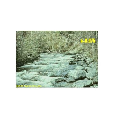
R-View - Visual Guide Software
R-View is a visual guide for selecting Manning’s roughness values in natural rivers and man-made channels using photographic information. It is based on U.S. Geological Survey’s publication entitled “Roughness Characteristics of Natural Channels” by Harry H. Barnes, Jr., Water Supply Paper 1849. R-view is intended for use by hydrologists, hydraulic engineers, geologists, geomorphologists, and practitioners of environmental engineering. In R-view a total of 100 photographic images is included to cover a wide range of channel conditions.