Kermap products
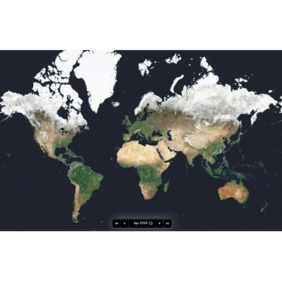
Model Nimbo - Earth Map and Time Machine
Nimbo Earth Online is a revolutionary platform that combines high-frequency satellite imagery updates, clarity, data diversity, and ease of use like no other. Offering cloud-free monthly updates with a resolution of 10 meters per pixel, Nimbo provides up-to-date views of Earth, unlike Google Earth which can have outdated images by several months or even years. This platform uses Sentinel 1 and 2 images from the EU’s Copernicus program, processed through Kermap's exclusive deep-learning techniques to clear clouds and harmonize colors. Nimbo allows users to explore detailed satellite images via a highly intuitive interface for free, making it ideal for students, researchers, journalists, environmental professionals, and geography enthusiasts. The platform features various data layers, 3D views, image comparison tools, and timelapse animations. Additionally, it offers high-quality basemaps compatible with GIS software, which can be accessed and utilized through an API token. By democratizing access to satellite data, Nimbo aims to support climate action and environmental monitoring, providing a valuable tool to measure, predict, and adapt to changes on our planet.
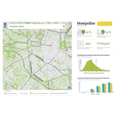
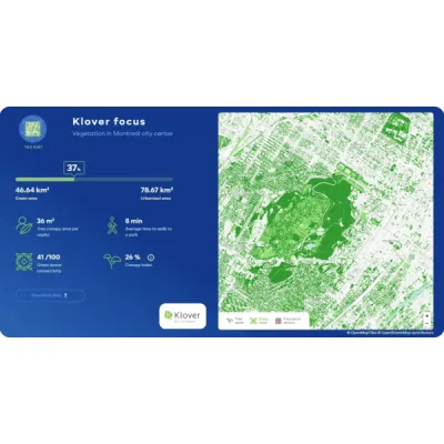
Nos Villes Vertes
Launched in 2019, Nos Villes Vertes is an innovative initiative by Kermap that aims to provide comprehensive and detailed data on the tree population across France's 36,000 towns and cities. Utilizing high-resolution aerial photographs from the national geographic institute IGN, Kermap employs sophisticated AI techniques, particularly deep learning models based on neural networks, to process this massive dataset. The project involves the unprecedented analysis of IGN's entire 20-terabyte, 20-centimeter orthophotographic dataset, completed in an impressively short timeframe through an IGNFab incubation contract. The platform simplifies complex data into user-friendly visualizations, offering easily interpretable indicators such as tree coverage ratio and tree surface per capita. This tool is designed to help local authorities and citizens alike understand urban vegetation and underscores the vital importance of trees in urban settings, thereby contributing to public interest technology.