Pixxel
2 software found

Pixxel software

Hyperspectral Imagery Software

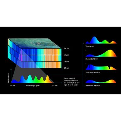
Pixxel's hyperspectral imaging satellites are uniquely designed to beam down data in hundreds of wavelengths to detect problems that are invisible to today's satellites. The constellation is designed to provide global coverage at a revisit of every 24 hours.

Pixxel - Aurora Earth Observation Studio Software

Aurora, developed by Pixxel, is an Earth Observation Studio designed to transform satellite imagery into actionable insights, creating a seamless analysis experience. By leveraging remote sensing technology, it aims to make Earth Observation data accessible to a wide range of users, enabling them to spectrally fingerprint the Earth in new ways. The platform provides access to an extensive archive of open-source remote sensing datasets and Pixxel’s hyperspectral imagery, alongside a marketplace of analytical models in a no-code environment. Aurora's key features include pliability in workflow customization, an intuitive user interface, and analytical model implementation, reducing the typical software learning curve. It facilitates multi-dimensional visualizations of satellite data and incorporates specialized machine learning algorithms. Aurora’s interoperability permits integration from various data sources and offers one-click insights via automated workflows, serving diverse industry requirements and supporting decision-making with high precision in fields like agriculture, energy, and government.