

Quality Positioning Services B.V. (QPS) software
Other Software
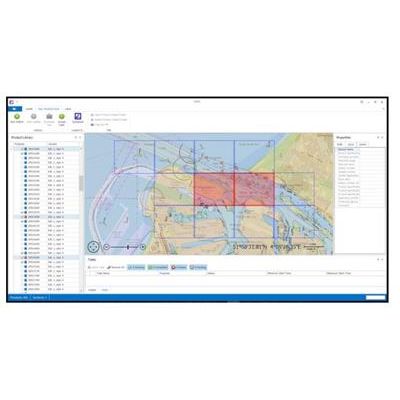
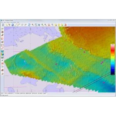
Qarto and Qomposer - Optimised ENC Production Software
Why Qarto vn3? The strength of Qarto is the very fast and automated ENC production. Qarto makes possible the short turn-around times from survey to chart that are necessary for the safe operation of the busy waterways e.g. in the Westerschelde and the Port of Rotterdam. Qarto can be part of your ENC Production suite that is built on ArcGIS - the system consists of three primary pieces: ArcGIS for Maritime: Bathymetry, ArcGIS for Maritime: Charting and ArcGIS for Maritime: Server. Or Qarto can operate standalone, using the QPS gridded data file to store the bathymetry data (each cell has many attributes including Date) and ENC base cells made available by 3rd party tools. Qarto is bundled with Qomposer, the QPS tool for ENC edits. Qomposer can import source files like CAD and imagery files, or the current S-57 and then be used to export a new S-57 after changes have been made.
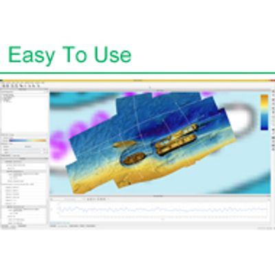
Qimera - Hydrographic Processing Evolved Software
We have conducted several usability studies with groups of clients and have taken our findings from that to improve the user experience for basic point cleaning in the Slice Editor. The usability studies also gave small but good ideas for improving the Instant Surface Filtering, based on design principles established in Qloud.
Qastor - Precise Navigation, Piloting and Docking Software
Qastor is a precise navigation, piloting and docking software application that was first released in 2000. Although primarily designed as an ECS for piloting operations, Qastor has also proven to be a useful navigation tool in several other fields including Ship Trials, Oil Rig Positioning, Inland River Barges, SPM Approaches, Ferry Operations, Oil and Gas Tanker Approaches and Docking, Patrol Vessels and Tugboat Operations. Using wired or wireless methods, Qastor interfaces to most devices outputting NMEA data strings to AIS transponders/receivers and to the QPS Connect Server, which is currently supplying meteorological data to Qastor users, but also capable of distributing other types of information.
Fledermaus - Model 4D - Geo-Spatial Processing and Analysis Tool
Fledermaus is the industry leading interactive 4D geo-spatial processing and analysis tool. With the release of Version 7.0 we have moved this to the next dimension: the addition of a fully integrated time reference allowing users to work in a true space and time environment. Commercial, academic and government clients use the Fledermaus software worldwide. They use the software to interact with massive geographical datasets of numerous data types for ocean mapping and land-based projects. The intuitive 4D display and interaction allows clients to rapidly gain insight and extract more information from their underlying data. This provides our clients with added value in data processing efficiency, quality control accuracy, data analysis completeness, and project integration, that promotes clear communication.
QINSy - Quality Integrated Navigation System)
QINSy - Model Multibeam - Integrated Navigation System Software
QINSy is an integrated navigation system software package used extensively worldwide for acquiring and processing multibeam data. The primary philosophy behind QINSy is to save time in processing, and the possible need for re-survey, by providing tools for real-time qualification of the raw data and on-the-fly correcting for offsets, motion, sound velocity refraction and height, to produce “final” xyz soundings as the survey proceeds.
Model Bundle - Integrated Navigation System Software
A bundle is a large, pre-fabricated pipe enclosing multiple other pipes and cables of lesser diameter. Ultimately installed on the seabed, these bundles are assembled on land and can range over 7 kilometers in length. When launched, the entire bundle is towed out to the parking location somewhere offshore using tugs deployed on both sides of the bundle. During the tow-out, the bundle is completely submerged, floating a few meters below the sea surface. To mitigate sagging of any portion of the lengthy bundle, it is necessary to make the bundle buoyant over its entire length.