
- Home
- Companies
- TdhGIS.com
- Software
TdhGIS.com software
TdhGIS - Vector based Spatial Analysis
The purpose of TdhGIS is to perform spatial analysis of data based on vector defined geometric data. This may include: NEW=> graphically create and edit geometric data, similar to the abilities in a CAD program. Import OpenStreetMap data. Use raster images as background for vector graphics. Transform coordinates based on the Proj4 library. Color polygons based on user data values using either Discrete intervals or Gradients. Allocate point data to user specified buffers for points, polygons and multilines (e.g. find all gas stations within 1 mile of a highway). Allocate point data to polygons. (e.g. assign structures to hydrological basins). Allocate polygon data to other polygons. (e.g. allocate population data by census block to political boundaries). Create thiessen polygons (e.g. for all hospitals within a state, define the areas where a particular hospital is closer than any other).
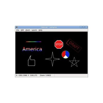
TdhCad - Vector Graphics Simplified
Features;Display Grids with identifiable and relocatable Cells. Click and drag to create entities of many shapes. Move, rotate and resize entities. Move points to reshape entities. Create groups containing entities and other groups. Create paths containing lines and curves. Copy and paste entire entities or points between entities. Change properties including color, width and dashes. Apply color gradients to entities and groups. Add a note to any entity. Use any number of layers. Merge drawings. Export drawings to SVG, PNG or PDF files. Save drawings within project databases. Use calibrated raster images as background for drawings. More, including Snap, Virtual Points, Arrows and FlipY.
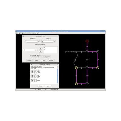
TdhGISnet - Shortest Path Analysis
Import OpenStreetMap Data by specifying tags for the ways (links) to be imported. The purpose of TdhGISnet is find and display the shortest path for a network of roads, communications links, etc. This may include:The shortest path between any 2 points in the network The shortest path between a starting point and any one of a set of potential end points (nearest location). The shortest path between a starting point and an entire set of intermediate points (travelling salesman). The shortest path for an entire set of points in a specified order Add a node anywhere, permanently or temporarily, by clicking or specifying coordinates. Assign links to layers that may be included or discluded from path analysis. Data is stored in an open database allowing manipulation by other software.
TdhTrails - Mobile Device Location App
The purpose of TdhTrails is to report location relative to a defined network using coordinates obtained from the mobile device on which the app is running. Networks used by TdhTrails are defined within an sqlite database that may be created, viewed and edited using the TdhGISnet personal computer software. Coordinates used by the network may be longitude/latitude or any coordinates that can be obtained by converting from long/lat data using the Project4 library.
TdhZones - Mobile Device Location App
The purpose of TdhZones is to report location relative to defined polygons (geographic zones) using coordinates obtained from the mobile device on which the app is running. Polygons used by TdhZones are defined within an sqlite database that may be created, viewed and edited using the TdhGIS personal computer software. Coordinates used by the polygons may be longitude/latitude or any coordinates that can be obtained by converting from long/lat data using the Proj4 library.