
VertiGIS software
VertiGIS Network
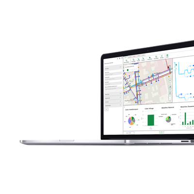
VertiGIS - Network Explorer Software
VertiGIS Network Explorer provides a robust platform for accessing and analyzing network data for utility management, suitable for both online and offline environments. This tool is designed to facilitate easy sharing and correlation of data, with capabilities to interpret data streams from sources such as smart meters and grid operations. The platform allows users to visualize network relationships and events, presenting results in various formats including maps and reports. It supports the creation of schematic diagrams for better understanding of complex logical relationships. Users can alternate between 2D and 3D views to better assess spatial data and infrastructure interactions. Additional features include sketching, noting, and dimension measurement on maps, along with flexible printing options. VertiGIS Network Explorer is customizable through a web-based designer, minimizing the need for complex custom development, making it a cost-effective and comprehensive solution for utilities looking to optimize their network operations.VertiGIS Studio
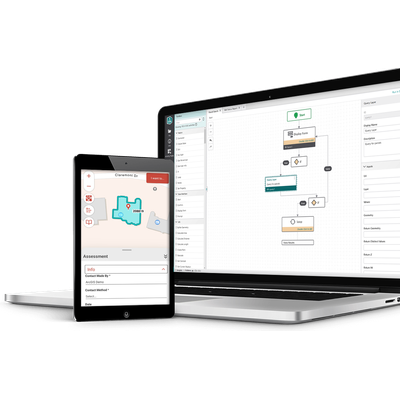
VertiGIS - Studio Workflow Software
VertiGIS Studio Workflow is a robust solution designed for modern business environments seeking to enhance efficiency and streamline complex tasks. By utilizing a low-code/no-code framework, it empowers organizations to create automated workflows that integrate smoothly with existing systems. This platform features a drag-and-drop Workflow Designer that simplifies the creation and sharing of workflows, suitable for ArcGIS Online or Portal environments. With a library of over 200 pre-built activities, users can quickly automate tasks without the need for extensive coding knowledge. Its offline capabilities ensure uninterrupted productivity in field operations, even in areas with limited connectivity, by enabling data capture and synchronization when connectivity is restored. The flexible form builder facilitates the design of custom interfaces for precise data collection, enhancing user interaction and data accuracy. Additionally, seamless integration with external databases and enterprise systems enhances interconnected workflows, driving organizational innovation.
VertiGIS FM
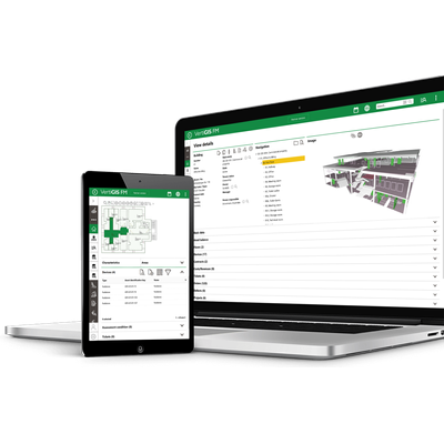
VertiGIS - Robust Facility Management Software for FM Buildings
VertiGIS FM Buildings is a robust facility management software designed to optimize the management of properties and buildings, both owned and leased. It enables efficient handling of crucial processes such as cleaning, inventory management, and key access control, ultimately supporting the occupants of these facilities. With standardized information documentation through proven templates, it enhances the clarity of property, room, and asset data. The software integrates GIS, CAD, and BIM interfaces to analyze spatial relationships, proving indispensable for asset and feature documentation. It features digital and barcode-supported inventory procedures, centralizing item tracking, location, and warranty documentation. Cleaning processes are meticulously organized to facilitate cost calculation, supplies management, and invoicing. Moreover, it includes digital key management, streamlining authorization processes seamlessly. VertiGIS FM Buildings adeptly manages facility reservations, asset conditions, and optimizes workplace safety and health protocols, constantly aligning with legal obligations.VertiGIS ConnectMaster
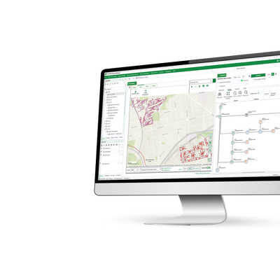
VertiGIS ConnectMaster - Network Modelling Platform Software
The VertiGIS ConnectMaster is a powerful network modelling platform designed to model the layer structure of telecommunications networks effectively. It integrates cutting-edge geographic mapping capabilities provided by Esri's ArcGIS® and extends this with tabular and schematic viewing, editing, and reporting functionalities. This system supports both the physical and logical layers of a network within a single platform, accommodating the creation of component types for various passive and active equipment. These tools allow users to create topologies for each network layer, building connectivity within and between layers based on predefined rules. Engineers benefit from high-end geographic and schematic mapping capabilities, optimizing the planning, building, and operational stages of network projects. The platform offers extensive configuration and integration options, ensuring scalability from small-scale implementations to complex networks with large operations teams, all while enhancing resource optimization and user productivity.M4