
- Home
- Companies
- Phoenix LiDAR Systems
- Products
- Phoenix-Slam - Conquer Gps-Denied ...
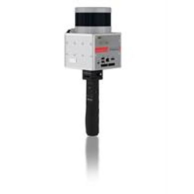
Phoenix-Slam - Conquer Gps-Denied Mapping System
The new Phoenix SLAM, slated for an early-2019 release, makes Phoenix LiDAR products more versatile by offering a dependable tool for mapping GPS-denied environments, such as underground mines and indoors.
Convert any Phoenix SCOUT model into a SLAM-compatible LiDAR Solution
The new Phoenix SLAM makes Phoenix LiDAR products more versatile by offering a dependable tool for mapping GPS-denied environments, such as underground mines and indoors. With the addition of augmented reality glasses, any Phoenix LiDAR SCOUT series model can be converted into a SLAM-compatible solution using the on-board software, navigation system and sensor for SLAM. Additionally, the Phoenix SLAM extends previous mapping solutions by supporting hybrid mapping modes: sparse GNSS fixes before, during and after SLAM acquisition can be used to eliminate drift and properly reference data in space and time. Existing ground control points can also be tied into the solution to ensure that deliverables align with ground truth.
- Map indoors and in other GPS-denied environments
- Automatic loop-closures eliminate drift
- Manual constraints allow fine-grained control of point cloud alignment Use of GPS for absolute timing, automatically georeferences the point clouds, and removes driftWeight: 2.2 kg / 4.9 lbs.
- Ground Control Points from any source can be used to further align the point cloud to known positions.
- Indoor Environments
- Outdoor Environments
- Archaeology
- Disaster Assessment
- Civic Projects
- Underground Projects
- Construction
- Mining