

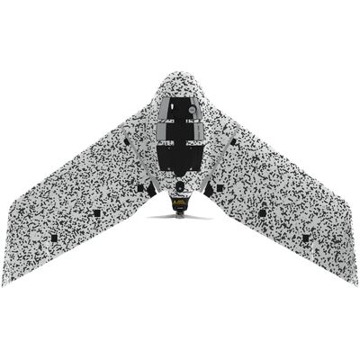
EagleNXT - Model eBee TAC -Cyber-Secure Governmental And Tactical Mapping Drone
Perform in disconnected environments to act precisely. eBee TAC can be operated by one person and deployed in 3 minutes. 3D models, thermal and orthomosaics maps sharable locally.
- 1.5 cm / 0.6 in mapping accuracy
- 90 minutes flight time
- 500 ha / 1,235 ac in a single flight
- 1.6 kg / 3.5 lbs
- Radio data link with AES-256 encryption
- Drone log file suppression
- Encrypted SD card
- Silent radio mission
- Low visible signature at 300 m / 984 ft AGL
- Acoustically undetectable at 300 m / 984 ft AGL
- Integrable with Google Earth Enterprise (GEEP)
- Designed and assembled in Switzerland
Efficiently map up to 500 ha / 1,235 ac while flying at 120 m / 400 ft.
With a flight time of 90 minutes and a flight range of 55 km / 34 mi, eBee TAC can cover large and inaccessible areas.
Thanks to its light weight, eBee TAC fixed-wing has the best ratio energy/MTOW compared to heavier VTOL drones, offering better energy efficiency.
eBee TAC swappable cameras allow you to collect data that can be used via the encrypted SD card for analysis and decision-making.
Camera options include RGB, 3D (patented) and thermal payloads for night flights.
With the RTK / PPK optional software, the tactical mapping drone achieves an absolute accuracy down to 1.5 cm / 0.6 in, without ground control points (GCPs).
eMotion drone management software for eBee TAC includes the Military Grid Reference System (MGRS), the geocoordinate standard used by NATO.