

- Home
- Companies
- LandScan, LLC
- Products
- Digital Soil Core
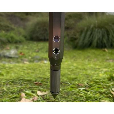
Digital Soil Core
The Digital Soil Core (DSC) is a probe with 7 independent sensors that is pushed into the ground at a continuous rate that enables the DSC to characterize the full soil profile to a depth of 120cm+ in about 1 minute. The DSC is part of the LandScan Platform for Discovery site characterization and analysis system where it is digitally synchronized with other complimentary technologies. While LandScan is focused on agricultural applications of the DSC, there are many other applications outside agriculture as well.
The DSC can be used to investigate and monitor the soil-water profile relationship under different irrigation practices throughout a growing season or used to baseline and monitor soil carbon and health over time under different practices. It can be used to set up research plots to avoid data noise caused by changing soil conditions within plots or understand and account for the variability if it can’t be changed. If seeds, microbes, fertilizers, and irrigation technologies work differently in different soils then understanding the soils in which they are developed and tested will bring them to market faster and with more confidence.
Outside of agriculture, the DSC can be used for mineral exploration, natural landscape assessment, archeology, levee and dam investigations, and much more.
Sometimes you need a map of the soil and the current vegetation, or lack thereof, isn’t important. In these instances, LandScan may still utilize remote sensing for DSC location targeting, but we also integrate a best-in-class off-the-shelf electromagnetic induction (EM) sensor and obtain an initial screening of the response from this sensor integrated with high-resolution topography data. It is very important to further delineate the variability detected with the EM sensor, as equivalent EM responses very rarely guarantee identical soil profiles even within the same field.
The ASAE measurement is taken ‘uphole’. The ASAE specification assumes that, because the rod used to insert the tip into the soil has a smaller diameter, that no friction occurs along the rod as it is inserted. If it did, then the measurement above would be a function of both tip resistance and friction along the rod. In reality, and in practice, there is always friction along the rod meaning the uphole measurement is unable to resolve the source of the force.
Another major difference is that the ASTM specification contains a sleeve sensor that measures friction, also downhole. This additional sensor enables the tool to separate bearing strength from cohesion, allowing the tool to properly attribute an increase in push resistance to a soil with more clay versus a soil with more sand. Is an elevated cone index associated with a change in density, or a change in texture? The ASTM specification can tell the difference whereas the ASAE tool cannot.
Like the tip and sleeve, these two sensors are also independent of one another, but work closely together both in physical and data space. Measurement of both are performed at the tip of the DSC where they play an important role in the calibration and interpretation of the other sensors.
Permittivity is the ability of a material to store electrical potential energy under the influence of an electric field. LandScan has engineered a capacitance sensor that generates data useful for the precise estimation of water and other physical such as mineralogy and density. The electrical resistivity works with the permittivity sensor to measure salinity and can also be used to characterize clay content.
If you close your eyes and listen to someone walking on gravel, you can estimate the size of the gravel they are walking on. In much the same way, but with far more sophisticated acoustic sensing capability, the DSC ‘snap crackle pop’ sensor is used to estimate coarse fragments and distinguish between varying materials in the soil. There are many sound dimensions, most beyond the human’s ability to hear, obtained through advanced signal processing that tell LandScan something different about each different soil horizon. I encourage you to turn your sound up and listen to some rock music!