

Geophysical Survey Systems, Inc., (GSSI)
- Home
- Companies
- Geophysical Survey Systems, Inc., ...
- Products
- GSSI - Model UtilityScan - GPR System ...
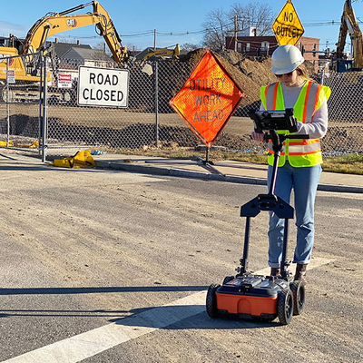
GSSI - Model UtilityScan -GPR System for Utility Locating
Locating and marking underground utilities in real-time in the field has been a powerful application of ground penetrating radar (GPR) for many years. A knowledgeable utility locator with a GPR system as part of their toolbox is able to accurately identify buried utilities. UtilityScan is built for the utility locating professional to accelerate workflow from target detection to reporting.
Most popular related searches
utility locating
ground penetrating radar (gpr)
ground penetrating radar
ground penetrating radar system
underground storage tank
underground utility
metal locating
utility locating GPR
locating underground utilities
utility locating ground penetrating radar
-
Max Depth: 10 m (35 ft)
-
Antenna Frequency: 350 MHz
-
Weight with Tablet & Battery: 16.8 kg (37 lbs)
-
Storage Capacity: 512 GB
-
Optional Software: RADAN 7 for UtilityScan, RADAN 7
-
Accessories: Geode GPS, Transit case, Model 626 survey cart, Model 656 survey cart
The UtilityScan is typically used to:
- Scan utilities – metallic and non-metallic
- Locate water lines
- Detect voids and underground storage tanks (USTs)
- Identify soil and foundation characteristics
- Locate shallow objects for archaeology
- 350 HS antenna (350 MHz)
- Panasonic G2 Toughpad
- Lithium-ion battery (2)
- Dual-bay battery charger
- Rugged 2 m ethernet cable
- LineTrac, optional
- Sunshade for G2 Toughbook
- Quick Start Guide
- 2-year warranty