

Geophysical Survey Systems, Inc., (GSSI)
- Home
- Companies
- Geophysical Survey Systems, Inc., ...
- Products
- GSSI - Model UtilityScan Pro - Utility ...
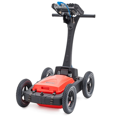
GSSI - Model UtilityScan Pro -Utility Mapping and Locating GPR System
With UtilityScan Pro, users can quickly identify and mark the position and depth of metallic and non-metallic objects; including utilities such as gas, communications and sewer lines as well as underground storage tanks and PVC pipes. Based on the SIR 4000 controller, the UtilityScan Pro provides the GPR professional with solutions to any underground locating situation.
Most popular related searches
underground utility locating
utility locating
underground storage tank
locating system
wheeled cart
sewer lining
geological investigation
underground locating
archaeology forensic
sewer line
-
Max Depth: 0-12 m (0-40 ft)
-
Antenna Options: 400 MHz, 300/800 DF, 350 HS
-
Weight: 27.2-34 kg (60-75 lbs) (cart dependent)
-
Storage Capacity: 32 GB
-
Optional Software: RADAN 7 for UtilityScan, RADAN 7
-
Accessories: LineTrac, Juniper Geode GPS, Tripod for 3-wheel survey cart
The UtilityScan Pro is typically used for:
- Underground utility detection
- Environmental remediation
- Damage prevention
- Geological investigation
- Archaeology
- Forensics
- Road inspection
- SIR 4000 Control Unit
- 400 MHz, 300/800 DF, or 350 HS Antenna
- Choice of 3-wheel or 4-wheel cart
- 2 m control cable
- SIR 4000 sunshade
- SIR 4000 AC/DC power supply
- Lithium-ion battery (2)
- Dual-bay battery charger
- Transit case
- 2-year warranty